Heath Street cycleway is a crucial segment in a six-part East-West regional cycleway connecting Canada Bay (in Sydney’s inner west) with the western suburbs.
The Heath Street section was enabled by $7 million grant from the NSW Government (New cycleway to transform the City of Canada Bay, 03 August 2020) as part of the Parramatta Road Urban Amenity Improvement Program (PRUAIP).
Canada Bay Council now plans to remove the cycleway it received state funding for. Cycleways are life saving infrastructure for cyclists and provide numerous positive externalities.
In this blog post I:
- Show the council is removing the cycleway while claiming to “modify” it.
- Show the council is removing the cycleway due to the third-party report.
- Outline errors and flaws in the engineering report prepared by a third party (which has now been hidden from the Canada Bay Council website).
To support my analysis I;
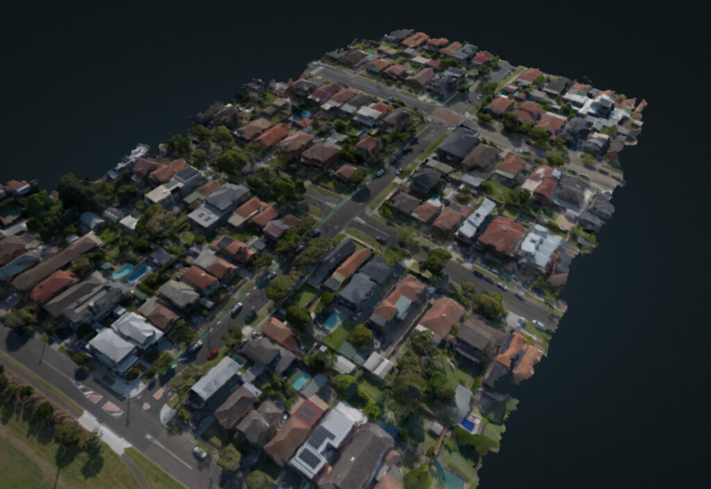
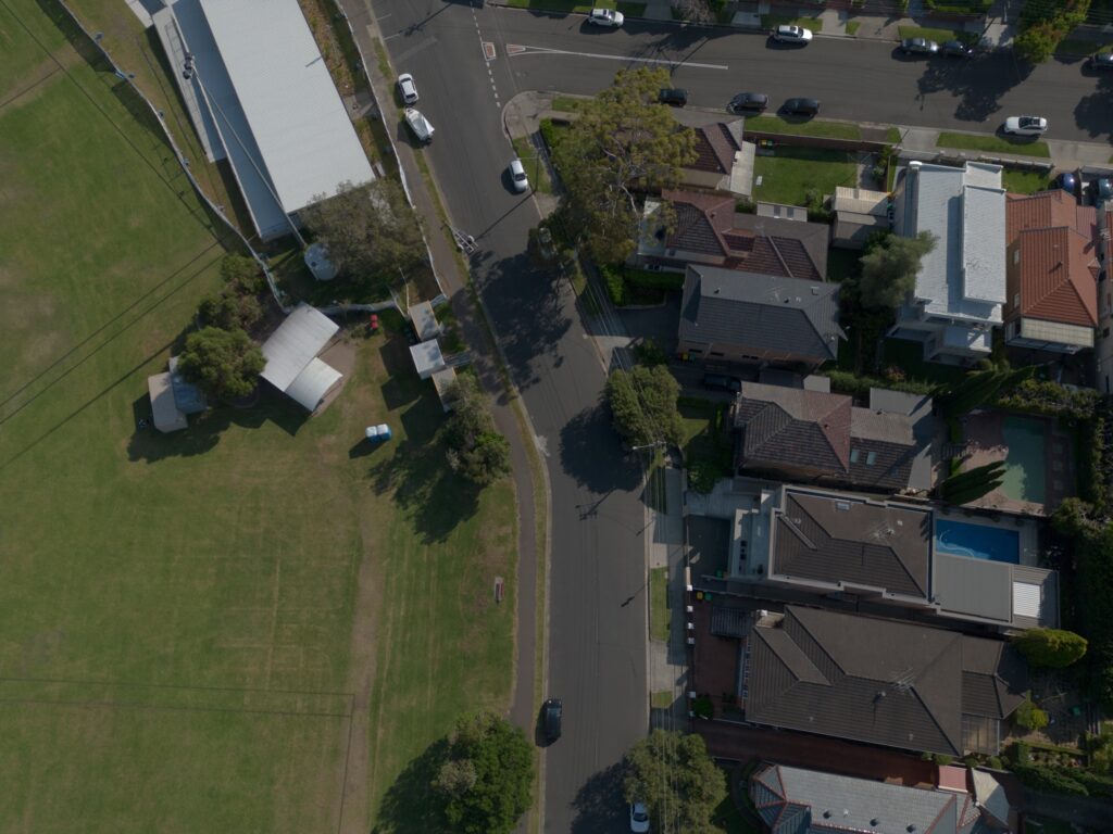
- conducted a drone aerial imagery survey using a commodity drone (following CASA laws)
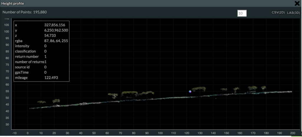
- used the open-source photogrammetry software OpenDroneMap software to process this aerial survey into a high-accuracy 3D mesh and pointcloud (with 4.2 cm average ground sampling distance)
- used the pointcloud to take measurements on the street in 3 dimensions
- created ortho-rectified aerial imagery from the pointcloud, which I uploaded to OpenDroneMap
- captured on-the-ground imagery using Mapillary
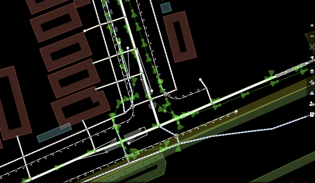
- used the above data to survey the street in OpenStreetMap in high resolution
- released all the above data as open source to enable reproduction & further analysis
Update 30/03/2023, Canada Bay Council voted to remove the cycleway. A summary by David Martin (via BayBUG FB, shared with permission):
Canada Bay Council on Tuesday night voted to accept Traffic Committee’s recommendation to remove the uphill cycleway in Heath St Five Dock, just installed in August 2022.
Note that TfNSW voted on TC against the recommendation, refuting the arguments put forward (re road width, accessing driveways, sight lines at Heath/Rickard). Transport strongly supported the benefits of the cycleway for bike riders and in slowing motor vehicle traffic on Heath St. Transport “offered design support to assist Council in developing a concept design that balances all user requirements” and that “Council consider deferring the decision on removal of the [cycle] path pending the outcome of a design review conducted in partnership with Council”. This offer was repeated in a motion from Cllr Jago(Greens)during consideration of the TC recommendation but did not receive a seconder. (NB Both Labour councillors were absent.)
There were five speakers against TC’s recommendation: from BayBUG, Bicycle NSW and the [Mortlake-Cabarita]Peninsula Action Group.
The lack of support from the Mayor (Tsirekas) and the TC chair (Cllr Megna) for anything cycling was palpable. After our first speaker presented, the Mayor asked the rest of us whether we really had anything in addition to say. We all claimed our 5 minutes.
Cllr Megna put the formal motion, spoke to it, and in doing so diverted to a rant about cyclists riding across the wombat on Great North Road (at Henry/Barnstaple) and allegedly knocking down old ladies. Tsirekas re-directed him to the Heath St issue. The motion was carried with only Jago dissenting.
This was the most blatant anti-cycling (and active transport) views that I’ve heard from our councillors. It doesn’t augur well for the future.
Also, not to forget that we met with Mayor Tsirekas in February 2018 and he undertook to produce a revised Canada Bay Bike Plan; nothing has eventuated.
Update 11/04/2023: Unconfirmed reports that the demolition of the cycleway has been delayed for a week, or possibly to the end of the month.
I have shared all the data I captured under an open license so that all measurements are reproducible.
- orthrectified imagery (CC BY-NC 4.0): https://map.openaerialmap.org/#/151.1388087272644,-33.8689546011284,17/user/62e7e060d84998000537975e/641e61d31a8878000512120f
- 3D model (
.obj) with textures (CC BY-NC 4.0): files.jakecoppinger.com/heath-st-scan/heath-st-textured-model.zip - pointcloud (
.laz) (CC BY-NC 4.0): files.jakecoppinger.com/heath-st-scan/Heath-Street-georeferenced_model.laz
I welcome any comments, contributions, constructive criticism or feedback either via comments below, on Mastodon (@[email protected]), or privately to [email protected].
Note: I am not a traffic engineer and I do not currently have any formal geospatial or civil engineering training. However, I am passionate about the safety of people on bicycles, the improvements in urban space their uptake brings and enjoying tinkering with open source geospatial tools & data in my spare time.
People die on Sydney roads because of the lack of safe, separated bicycle infrastructure.
I hope this analysis contributes to the advocacy efforts by BicycleNSW, the Canada Bay Bicycle User Group (BayBUG) and others in retaining this infrastructure paid for by the taxpayers of NSW.
Table of contents:
Modifying or removing infrastructure?
Misleading FAQ section
In the FAQ section, the Canada Bay website currently says this:
Does this mean Council is removing the cycleway?
https://collaborate.canadabay.nsw.gov.au/ewcycleway/seg1heathst
No. Council is fully committed to delivering the East-West Regional Route, and a cycleway will be maintained on Heath Street. This proposal is to modify the separate cycleway.
This suggests the cycleway won’t be removed. However, also in the FAQ sections, the Council states why they will “modify” the cycleway:
Why is Council proposing to modify the cycleway?
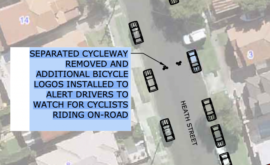
Council is responding to local community concerns regarding the dedicated cycleway, which was constructed in late 2022 and potential impacts to other users of the share space. Council received feedback on issues including but not limited to line of site concerns navigating through intersections and access to properties, increasing of traffic congestion on the road users and potential increase of hazards to pedestrians.
Council heard through community feedback, and through our own observations on site, potential increase of risk for some users of the shared space as result of the solution currently built.
Council took the decision to seek independent advice on the as built solution to assess the acceptable level of risk for all users of the as-built solution and provide advice on alternatives.
Council has received and considered this advice and are proposing to address the outcomes by providing a more balanced solution that considers all users of the shared space.
The proposed modifications intend to provide a more balanced outcome for all users while also maintaining cycling infrastructure.
This sentence is demonstrably false: “The proposed modifications intend to provide a more balanced outcome for all users while also maintaining cycling infrastructure.”
Sharrows or painted bicycle icons are not bicycle infrastructure!
Holding all else equal, compared to no bicycle route, a bicycle injury nearby sharrows was nearly twice as likely to be moderate, severe, or critical (adjusted odds ratio 1.94; 95% confidence interval (CI) 0.91–4.15).
Wall SP, Lee DC, Frangos SG, et al. The Effect of Sharrows, Painted Bicycle Lanes and Physically Protected Paths on the Severity of Bicycle Injuries Caused by Motor Vehicles. Safety (Basel). 2016;2(4):26. doi:10.3390/safety2040026
Changes to the council website
The Internet Archive (archive.org) Wayback Machine shows this diff of the council website copy.
The website has replaced the word removal with modification.
However, more has changed.
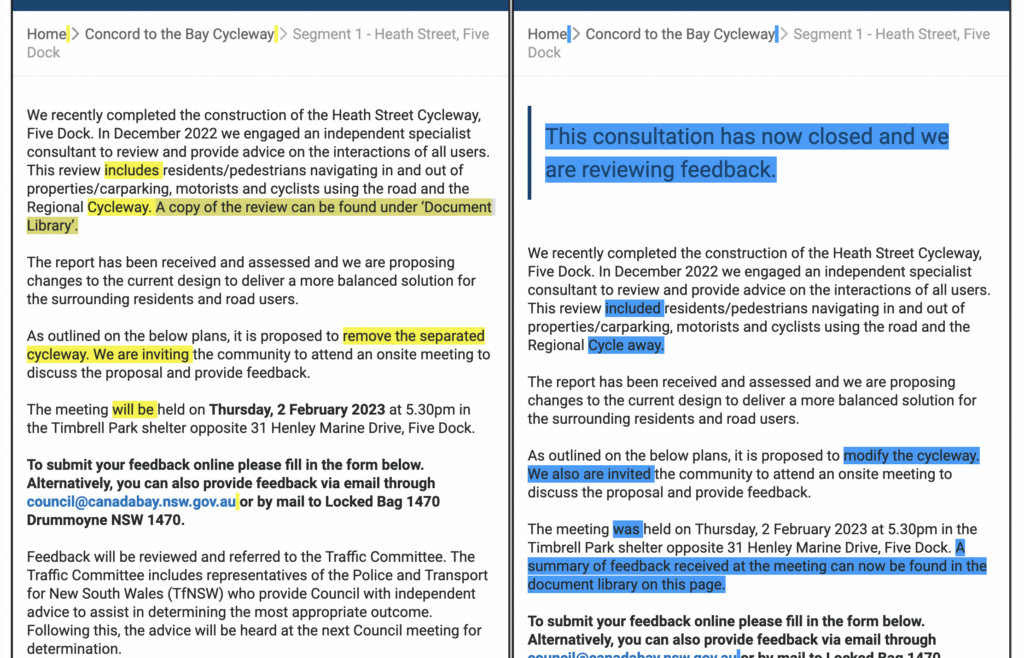
The copy of the “independent specialist consultant” report commissioned in December 2022 to “review and provide advice on the interactions of all users” has been removed from the website, along with any mention of it.
A hidden traffic report
In December 2022 we engaged an independent specialist consultant to review and provide advice on the interactions of all users. This review included residents/pedestrians navigating in and out of properties/carparking, motorists and cyclists using the road and the Regional Cycle away.
https://collaborate.canadabay.nsw.gov.au/ewcycleway/seg1heathst
Council took the decision to seek independent advice on the as built solution to assess the acceptable level of risk for all users of the as-built solution and provide advice on alternatives.
Council has received and considered this advice and are proposing to address the outcomes by providing a more balanced solution that considers all users of the shared space.
From the FAQ section “Why is Council proposing to modify the cycleway?“. Bold text my own highlighting.
The FAQ section makes it clear the “balanced solution” proposed is designed to “address the outcomes” of this traffic engineering report, on the merits of “acceptable level of risk for all users”.
This implies if the report has flaws then the proposed modifications may also have flaws.
As mentioned above, this report is no longer shown on the council website. Fortunately, the Wayback Machine (hosted by the Internet Archive) indexed the council project page 30th Jan 23, showing the now removed report on the right sidebar: https://web.archive.org/web/20230130232813/https://collaborate.canadabay.nsw.gov.au/ewcycleway/seg1heathst
The report link itself was not yet archived, but is still live. I recommend you read it while evaluating the below section: https://collaborate.canadabay.nsw.gov.au/download_file/7173/1457 (it is now archived at https://web.archive.org/save/https://collaborate.canadabay.nsw.gov.au/download_file/7173/1457).
Discussion of report
Introduction to body of report
In 2.1, it’s due to road line marking being offset from the centre of the road. The (sensible) recommendation is to move painted lines approaching traffic islands closer to the centre of the road. I have no concerns with this section.
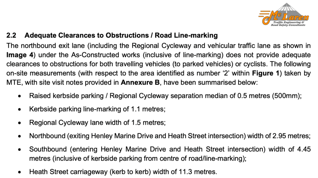
The following paragraphs appear in sections 2.2, 2.3 and 2.4 respectively of the traffic report.
Under a conservative approach, removal of the western kerbside parking lane would greatly improve the two-way traffic flow and exiting traffic travel lanes; however, traffic volume data could reduce the impact on kerbside parking given a lower-order requirement for passing opportunities; such that the removal of all subject on-street parking spaces would not be required.
Under a conservative approach, removal of the western kerbside parking lane would greatly improve two-way traffic flow, more aligned with the previous environment (but at the loss of on-street parking for residents, visitors and users of Timbrell Park); however, reinstating the previous kerbside parking with a shared two-way carriageway (for both vehicles and bicycles), pending future traffic volume data would be an improved and safer outcome.
Under a conservative approach, removal of the western ‘offset-kerbside’ parking lane (along Heath Street) would greatly improve the sight lines (approach sight distances), more aligned with the previous environment (but at the loss of on-street parking for residents, visitors and users of Timbrell Park). Further, as previously stated, reinstating the previous kerbside parking with a shared two-way carriageway (for both vehicles and bicycles), pending future traffic volume data would be an improved and safer outcome.
The similarity alarms me. The meaning of “conservative approach” is undefined. Each sentence suggests the conservative approach is removing the western kerbsite parking lane (to improve traffic flow and sightlines).
The first paragraph differs to the second and third later in the paragraph. Both the second and third claim that “reinstating the previous kerbside parking with a shared two-way carriageway (for both vehicles and bicycles), pending future traffic volume data would be an improved and safer outcome.”
Each of these paragraphs comes up in a different context.
In 2.2 (Adequate Clearances to Obstructions / Road Line-marking), a series of measurements is used to justify that the as-constructed works “does not provide adequate clearances to obstructions for both travelling vehicles (to parked vehicles) or cyclists.”
In 2.3 (Two-Way Passing / Carriageway Width (Heath Street)), a series of measurements is used to justify that “the depicted 4.2-metre-wide two-way carriageway is fundamentally insufficient for two-way passing/traffic given the context of Heath Street, Five Dock, the kerbside parking environment, Regional Cycleway and residential driveways.”.
In 2.4 (Approach Sight Distances (ASD)), one dash-cam photo, the cycleway width, and the road width are used to justify “As-Constructed works reviewed have reduced the approach sight distances (Image 5), specifically for drivers of vehicles undertaking a right-turn from Richard Street onto Heath Street. MTE witnessed vehicles ‘creeping’ into the intersection (and heard from local residents regarding this and other matters during the site visits), with the Heath Street declining at a gradient of approximately 10% [1:10] towards Timbrell Park being exacerbated by the shifting of the kerbside parking (to accommodate the Regional Cycleway path and 500mm concrete separation median) by approximately 2.25 metres.”
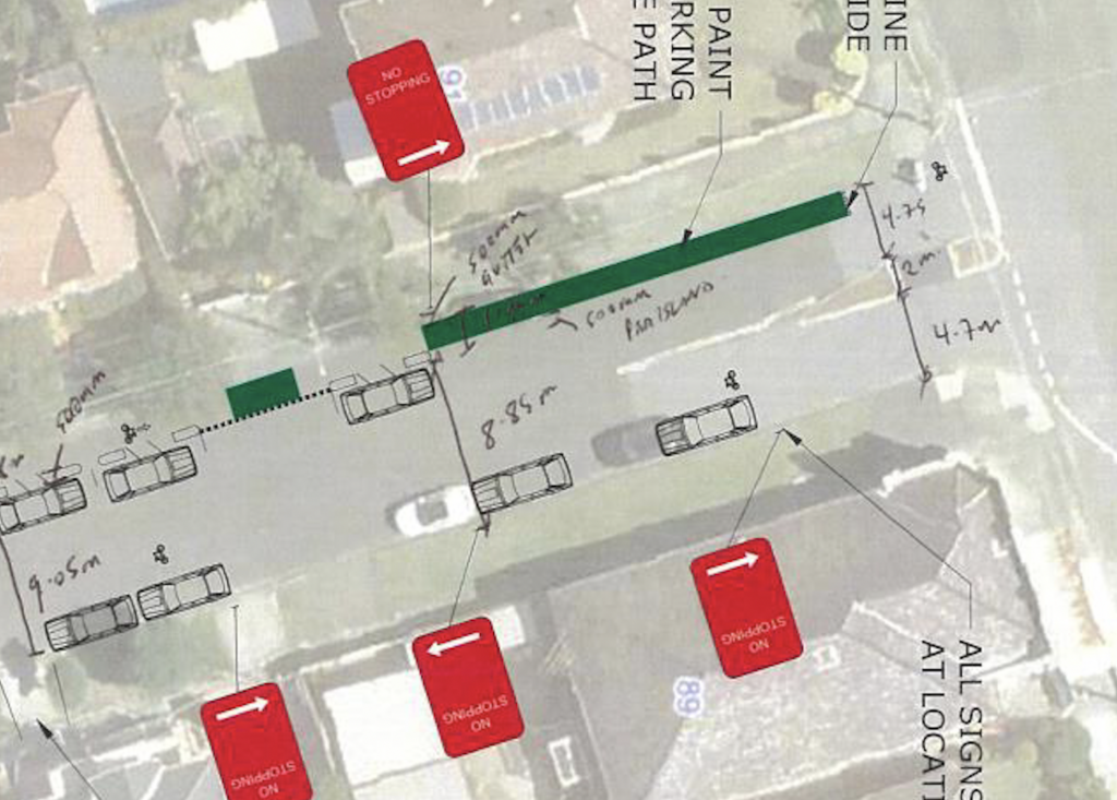
2.5 (Two-Way Passing (Heath Street on Approach to Intersection with First Avenue)) claims some measurements justify “The measured 8.85-metre-wide carriageway (inclusive of kerbside and offset-kerbside parking) within the proximity to the intersection of Heath Street and First Avenue is typically inadequate; however, a traffic volume based analysis should be undertaken given the importance of on-street parking with respect to the residentially and recreationally dense area.”
I now systematically examine flaws in the arguments of each of these sections.
Flaws in arguments of report body
2.2 Adequate Clearances to Obstructions / Road Line-marking
The report states “the As-Constructed works (inclusive of line-marking) does not provide adequate clearances to obstructions for both travelling vehicles (to parked vehicles) or cyclists”
- The creation of a separated cycle lane on Heath Street ensures a safe clearance (width) which cyclists can travel in
- Heath St does not have centre line markings. It functions as a yield street when required.
- “Depending on the number and arrangement of parked vehicles, they effectively become a single travel lane at certain times and places along the street, requiring slower, cooperative driving: one driver yields to another.” Yield street, NSW Movement and Place guidelines
- Resolving the reduced clearances due to road line marking may not even require the removal of parking spaces pending a traffic volume survey
- No suggestion of removing the cycleway is recommended under 2.2.
- There is a fairly major error in this section: “The northbound exit lane (including the Regional Cycleway and vehicular traffic lane as shown in Image 4) …” under “2.2 Adequate Clearances to Obstructions / Road Line-marking” is actually the southbound exit lane. The caption of Image 4 is “IMAGE 4: HEATH STREET (NORTH FACING) FROM THE INTERSECTION OF HENLEY MARINE DRIVE AND HEATH STREET”
2.3 Two-Way Passing / Carriageway Width (Heath Street)
> Under a conservative approach, removal of the western kerbside parking lane would greatly improve two-way traffic flow, more aligned with the previous environment (but at the loss of on-street parking for residents, visitors and users of Timbrell Park); however, reinstating the previous kerbside parking with a shared two-way carriageway (for both vehicles and bicycles), pending future traffic volume data would be an improved and safer outcome.
- This sentence claims removing the separated cycleway would be an improved and safer outcome. No evidence is presented for this.
- “Improved” in this sentence seems to means the retention of on street parking for private vehicles, not improved safety.
- Remember, the brief of the report according to the Council FAQ is “to assess the acceptable level of risk for all users of the as-built solution and provide advice on alternatives.”
2.4 Approach Sight Distances (ASD)
This section claims:
MTE witnessed vehicles ‘creeping’ into the intersection (and heard from local residents regarding this and other matters during the site visits), with the Heath Street declining at a gradient of approximately 10% [1:10] towards Timbrell Park being exacerbated by the shifting of the kerbside parking (to accommodate the Regional Cycleway path and 500mm concrete separation median) by approximately 2.25 metres.
- Vehicles “creeping” into give-way intersections is safe and desired lawful behaviour. The NSW Road Rules 2014 on the NSW Legislation website state:
give way, for a driver or pedestrian, means—
(a) if the driver or pedestrian is stopped—remain stationary until it is safe to proceed, or
(b) in any other case—slow down and, if necessary, stop to avoid a collision.
- Suggesting that there is any causal relationship between a 10% incline and motorists unsafely ‘creeping’ into an intersection is, quite frankly, ridiculous
- The statement “gradient … being exacerbated by the shifting of the kerbside parking … by approximately 2.25 metres.” is not theoretically plausible, possible or backed up by measurement or reason.
- There is no evidence of the gradient being increased by the shifting of the kerbside parking.
- Assuming a constant road camber gradient across the ride, shifting the kerbsite parking would not increase the north/south gradient, and would decrease the gradient across the road
- The statement “gradient … being exacerbated by the shifting of the kerbside parking … by approximately 2.25 metres.” is not theoretically plausible, possible or backed up by measurement or reason.
- Not only is this casual relationship ridiculous, the stated gradient of 10% is incorrect.
- The gradient on Heath Street south according to the pointcloud model generated by OpenDroneMap from aerial imagery is approximately 10 metres over 150 metres, or a 6.6% gradient
2.5 Two-Way Passing (Heath Street on Approach to Intersection with First Avenue)
The text is very similar to the text of 2.2
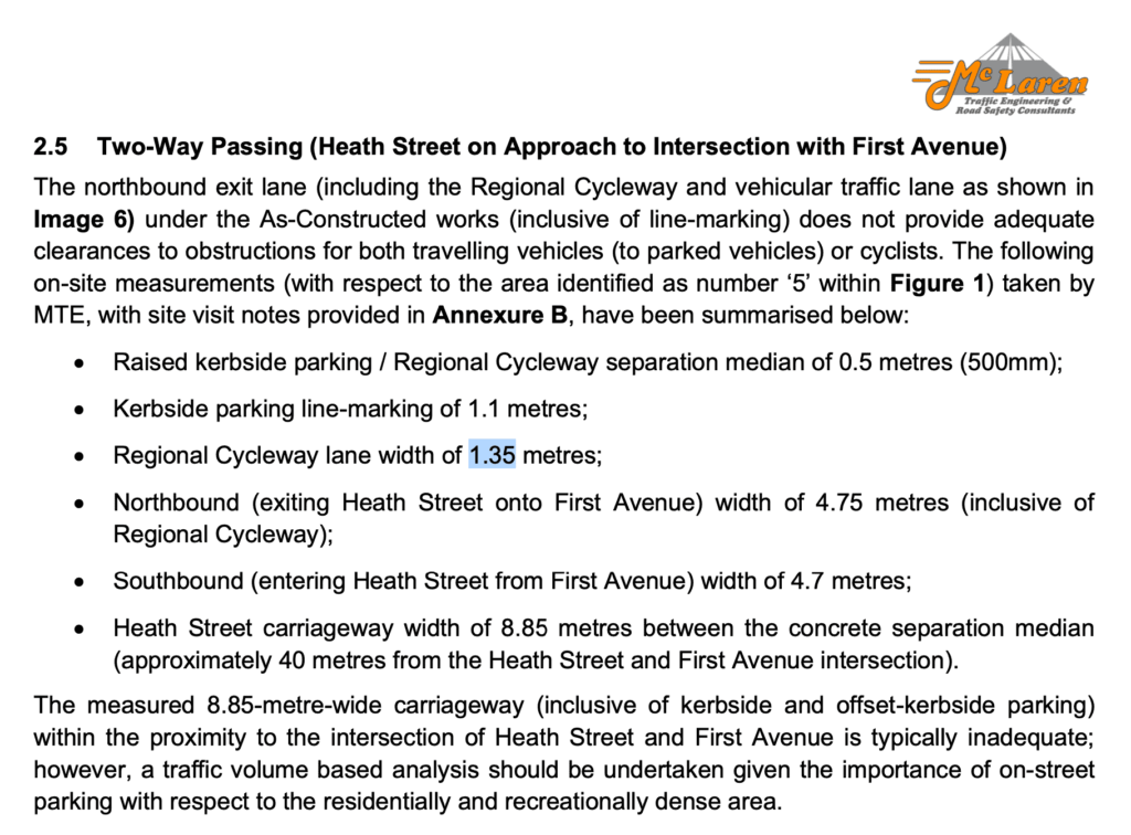
2.5 however includes an sentence at the bottom.
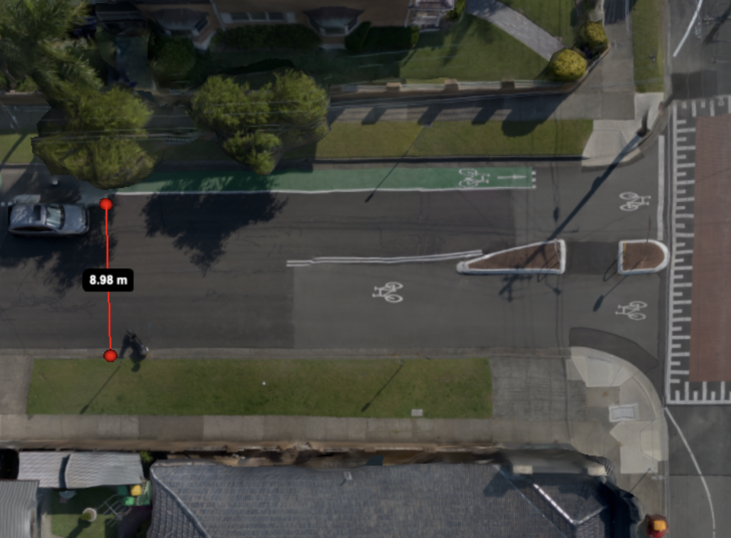
- The measurement of 8.85m street width just south of the traffic calming table may be incorrect
- > The measured 8.85-metre-wide carriageway (inclusive of kerbside and offset-kerbside parking) within the proximity to the intersection of Heath Street and First Avenue is typically inadequate; however, a traffic volume based analysis should be undertaken given the importance of on-street parking with respect to the residentially and recreationally dense area.
- “typically inadequate” does not state any relation to AS2890.5:2020 Clause 3.2 Parallel parking
- “given the importance of on-street parking with respect to the residentially and recreationally dense area” – the importance of on street parking on this street is discussed below under the “On street parking availability” heading

That concludes the analysis of the flaws in the body of the report. I now proceed to analyse flaws in the findings & conclusions of the report.
Overview of report findings & conclusions
- Report finding 1: Alignment issues for vehicles exiting from Henley Marine Drive onto Heath Street and conflicting with the offset-kerbside (western) parking lane;
- Report finding 2: Sight distances for drivers of vehicles exiting the residential driveways along Heath Street have been reduced, or otherwise restricted creating unsafe conditions;
- Report finding 3: Sight distances for drivers of vehicles performing right-turns from Richard Street onto Heath Street have been reduced, or otherwise restricted creating unsafe conditions;
- Report finding 4: The carriageway width of Heath Street has reduced resulting in fewer passing opportunities, restricting two-way traffic flow and creating the potential for hazardous “Head-on” collisions.
“In view of the foregoing, the resultant works have generally reduced the safety of all users for all movements along, across and access (i.e. residential access) via Heath Street. [conclusion 1]
Further, the As- Constructed works assessed have by-large introduced new risks and conflicts (i.e. trip hazards, reduced clearances and sight lines) between drivers of vehicles, pedestrians and cyclists between individual properties, public footpaths and the offset-kerbside parking. [conclusion 2]“
Analysis of flaws in findings
Report finding 1
The issue seems sensible, as does the resolution (resolved by repainting lines).
Report finding 2
Sight distances for drivers of vehicles exiting the residential driveways along Heath Street have been reduced, or otherwise restricted creating unsafe conditions;
(emphasis mine)
- No part of the report other than this finding mentions reduced sight distances at driveways
- Report heading 2.4 Approach Sight Distances (ASD) only addresses sight lines at the intersection: “works reviewed have reduced the approach sight distances (Image 5), specifically for drivers of vehicles undertaking a right-turn from Richard Street onto Heath Street”, not at driveways
- In case it isn’t obvious – the cycleway is flat, and the concrete bollards are ~15cm tall. Any sightline impact is due to private car parking on the public road, which could be reduced or moved with the stroke of a paintbrush.
Report finding 4
The carriageway width of Heath Street has reduced resulting in fewer passing opportunities, restricting two-way traffic flow and creating the potential for hazardous “Head-on” collisions.
- There is no evidence presented that reducing passing opportunities reduces the safety of the street
- Conversely, reducing passing opportunities reduces the potential for “hazardous “Head-on” collisions”
- Reducing lane widths and parking “should be considered” according to the TfNSW NSW Cycleway Design Toolbox (heading 3.1.3, pg 22):
- > To help achieve the preferred width of a bicycle path, the following measures should be considered to ‘gain width’:
– Reduce traffic lane width, especially if the road does not service public transport
– Reduce the number of traffic lanes, removing turning lanes or slip lanes, or introducing one-way traffic
– Reallocate space used for carparking
- > To help achieve the preferred width of a bicycle path, the following measures should be considered to ‘gain width’:
- Section 2.2 claims “traffic volume data could reduce the impact on kerbside parking given a lower-order requirement for passing opportunities; such that the removal of all subject on-street parking spaces would not be required”. This implies that if there is a low traffic volume the authors believe there is a “lower-order requirement for passing opportunities”
- There is no evidence presented that “restricting two-way traffic flow” reduces the safety of the street. The report is tasked to discuss safety and does not discuss increased traffic flow as a desired outcome (and nor should it be on a residential street with a cycleway).
- The road width has been reduced. Reduced road widths decrease the average speed of a street (Karim, D.M., 2015, June. Narrower lanes, safer streets. In Proc. CITE Conf. Regina (pp. 1-21). https://www.researchgate.net/publication/277590178_Narrower_Lanes_Safer_Streets. See below extract).
- If there is a head on collision the speed of the vehicles would likely be lower
- If there is a head on collision, it is less likely to be between a cyclist and a motorist, as the street now has a separated cycleway.
- If the risk of head on collisions between motorists is considered too high, reducing the signed limit from 50kmh to 40kmh or 30kmh (as recommended by 30please.org) would reduce the risk
- If there is a head on collision, cyclists not in the collision are likely to be protected by the parked cars separating the cycleway from the road.
Analysis of flaws in conclusions
Conclusion 1
the resultant works have generally reduced the safety of all users for all movements along, across and access (i.e. residential access) via Heath Street. [conclusion 1]
- The claim that the works have reduces the safety of all users for all movements along, across and access is demonstrably false.
- The works in introduced a safe separated cycleway, creating a safer environment for some of the most vulnerable road users (cyclists)
- The works narrowed road lane width. Narrowed road lanes (within reason) often improve safety of motorists and all other road users.
- Karim, D.M., 2015, June. Narrower lanes, safer streets. In Proc. CITE Conf. Regina (pp. 1-21). https://www.researchgate.net/publication/277590178_Narrower_Lanes_Safer_Streets
> Given that the empirical evidence favours ‘narrower is safer’, the ‘wider is safer’ approach based on personal or intuitional opinion should be discarded once and for all. The findings acknowledge human behavior is impacted by the street environment, and narrower lanes in urban areas result in less aggressive driving and more ability to slow or stop a vehicle over a short distance to avoid collision. Designers of streets can utilize the ” unused space ” to provide an enhanced public realm, including cycling facilities and wider sidewalks, or to save money on the asphalt not used by motorists. - > The ripple effects of carefully designed narrower streets are large (Kenneth and Chen, 2012). Combined with other safer design features (such as a planted median, bump-outs or bulb-outs), narrower lanes in off-peak periods act as defacto psychological design controls, inducing the maintenance of a safer range of vehicle operating speeds.
- Karim, D.M., 2015, June. Narrower lanes, safer streets. In Proc. CITE Conf. Regina (pp. 1-21). https://www.researchgate.net/publication/277590178_Narrower_Lanes_Safer_Streets
- There is no evidence presented for safety of movements across (excluding “residential access”) the street being reduced, or for which modes (pedestrian? cyclist?)
- A reduction of road width means less distance for a pedestrian to cross
- The second order effect of road width being reduced likely reduces the average speed of motorists on the road, further increasing pedestrian safety
- discussion of the safety of residential access & sightlines is below
Conclusion 2
As- Constructed works assessed have by-large introduced new risks and conflicts (i.e. trip hazards, reduced clearances and sight lines) between drivers of vehicles, pedestrians and cyclists between individual properties, public footpaths and the offset-kerbside parking. [conclusion 2]”
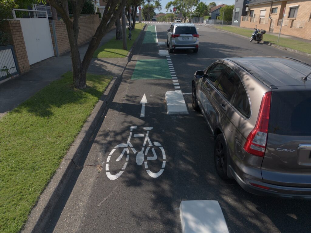
- works assessed have by-large introduced new risks … trip hazards…
- there is no other mention in the entire report of trip hazards
- assuming the “trip hazards” here is referring to the concrete islands separating the cycleway and the road:
- The TfNSW NSW Cycleway Design Toolbox under Heading 3.1.3 (pg 22) states:
> Kerb treatments provide separation between people walking and cycling. A slanted edge (less than 45-degree angle) is preferred, due to its forgiving design. Vertical edges (90-degree standard kerbs) pose a safety risk to people cycling, but may be considered when using existing kerbs and drainage (to reduce costs) or due to safety considerations for pedestrians (reduce trip hazards).- This implies that a 90 degree kerb (as used on Heath St) are preferred over slanted edge kerbs for reducing trip hazards.
- The concrete islands have a high colour contrast and are unlikely to be missed
- There are no concrete islands in front of driveways
- footpaths exist on both sides of the street, so walking north/south would be undertaken on the footpath rather than the road
- The TfNSW NSW Cycleway Design Toolbox under Heading 3.1.3 (pg 22) states:
- works assessed have by-large introduced new risks … reduced clearances…
- Heading “2.2 Adequate Clearances to Obstructions / Road Line-marking” says
> “Under a conservative approach, removal of the western kerbside parking lane would greatly improve the two-way traffic flow and exiting traffic travel lanes; however, traffic volume data could reduce the impact on kerbside parking given a lower-order requirement for passing opportunities; such that the removal of all subject on-street parking spaces would not be required.”- The report claims the reduced clearances due to road line marking may not even require the removal of parking spaces (let alone the cycleway) pending a traffic volume survey
- No suggestion of removing the cycleway is recommended under 2.2. The only suggested modification is moving the painted lines to be closer to the centre of the road.
- The heading also says “the As-Constructed works (inclusive of line-marking) does not provide adequate clearances to obstructions for both travelling vehicles (to parked vehicles) or cyclists”
- The creation of a separated cycle lane on Heath Street ensures a safe clearance (width) which cyclists can travel in
- Heading “2.2 Adequate Clearances to Obstructions / Road Line-marking” says
- works assessed have by-large introduced new risks … sight lines…
- No part of the report other than this finding mentions reduced sight distances at driveways
- In case it isn’t obvious – the cycleway is flat, and the concrete bollards are ~15cm tall. Any sightline impact is due to private car parking on the public road, which could be reduced or moved with the stroke of a paintbrush.
Other comments
On-street parking availability
At the time of survey, there was plentiful on street parking availability in the area. There was so much space that two boats and a caravan were on the adjacent street. The adjacent street width is very wide (10.76 metres).
Any reduction in parking availability on Heath Street would have a low impact on total parking availability in the area.

As mentioned above, I welcome any comments, contributions, constructive criticism or feedback either via comments below, on Mastodon, or privately to [email protected].
Note: I am not a traffic engineer and I do not currently have any formal geospatial or civil engineering training. However, I am passionate about the safety of people on bicycles, the improvements in urban space their uptake brings and enjoying tinkering with open source geospatial tools & data in my spare time.
People die on Sydney roads because of the lack of safe, separated bicycle infrastructure.
Further reading
Heath St cycleway
- https://bicyclensw.org.au/heath-street/
- https://micromobilityreport.com.au/infrastructure/policy-and-funding/new-separated-cycleway-earmarked-for-removal-by-sydney-council/
- https://www.bikenorth.org.au/2023/02/08/keeping-another-bike-lane-open/
- BayBUG Canada Bay Bicycle User Group videos
- Council forgets about climate emergency in order to bulldoze cycleway for car parking: https://youtu.be/DYcH7I8WnDI
- What does a successful cycleway look like?: https://youtu.be/H0Pyfl6u4ag
- Heath St cycleway three minute review: https://youtu.be/vHljtv72_zQ
- Heath St: https://youtu.be/w12PsLTDHM4
- Has the Heath St cycleway increased risk or decreased it?: https://youtu.be/B2bNAbzM_iA
- What are the changes in risk from building the Heath St cycleway – particularly for doorings?: https://youtu.be/CvY6kv9i3qc
Leave a Reply to Jake C Cancel reply