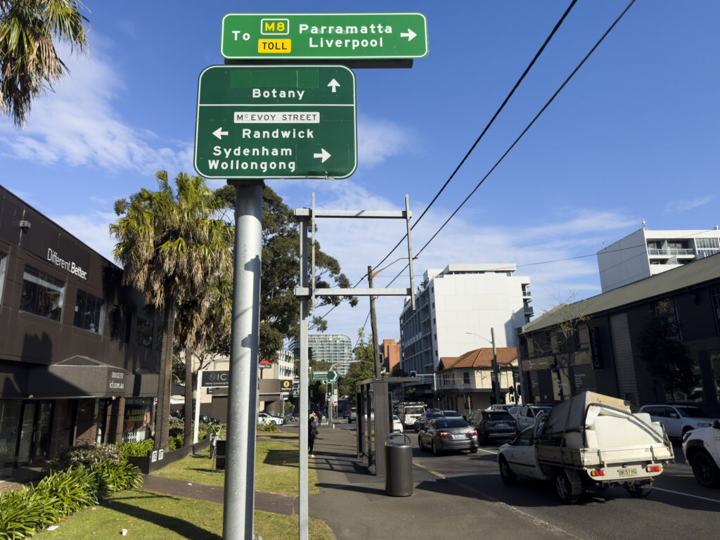
You read that right – just yesterday[a] TfNSW announced a proposal[3] to widen an inner Sydney road and demolish footpaths and trees (map[4]). In the year 2026. We desperately need more homes, we need more bus lanes, we need to ‘fix’ traffic – but this should be done by reallocating road space – per TfNSW’s great policy. The TfNSW fever dream of ”just one more lane” of urban road capacity will induce more vehicles, and will not ‘fix’ traffic.[5]
Some historical context: this is the intersection of both the Southern Arterial Route (~13,000 words, 168 references) and the Alexandria to Moore Park Project (~3,500 words, 80 references).[b] Let’s not pretend this is about buses – this is a smokescreen for a classic road widening project. The southbound AM peak bus lane is proposed precisely because that’s when there’s less southbound car traffic – because most folks are heading into the city for work. The word for this, is misdirection.
The project page includes a “Project documents” heading yet TfNSW couldn’t find any documents to put there. Would you get away with spending $22 million of taxpayer money without providing a decent reason? The time for attributing to stupidity is long gone: $22 million to build more lanes without a PM peak bus lane out of the CBD – is malice.
Where’s the evidence? Perhaps some bus delay data? Modelling of a bus lane all the way from that pedestrian crossing TfNSW ripped out at Harris St and Pyrmont Bridge Road[7][8][c][d] all the way down to Green Square – or am I dreaming? Imagine TfNSW openly releasing signal phasing, let alone vehicle volumes – the stuff of fantasy! Does anyone seriously believe the point of spending $22m is an AM peak-only bus lane away from the CBD? Is suffixing “…and bus corridor improvements” on a project really going to sneak this past the Ministers? This wouldn’t be the first time.[12][13][14][15][16]
What transport study found “57 vehicles would be spread across the alternative routes during the AM peak hour…“[3][e] I’ve made an informal[17] request to TfNSW for any transport studies or impact assessments – given a GIPA[f] wouldn’t arrive in time before the ‘feedback’ deadline. Join my blog mailing list if you want those cold hard PDFs as soon as I get them.
Make no mistake; this is a horrifying WestConnex project. ‘Improving’ this intersection was “Major design feature 4” in the November 2019 Alexandria to Moore Park Stage 1 REF[19]: 6 : 44 (PDF 62) , with the aim of “Improving intersection capacity”[19]: 5 (for cars). A2MP Stage 1 was carried out under WestConnex planning condition E40 b iii[g] and A2MP Stage 1 sits under the TfNSW Network Integrations team.[25]: 39 (PDF 41) Worse than a WestConnex project, the Government offloaded soaring spending onto the TfNSW Network Integration Program (the taxpayer)[h] – according to none other than the NSW Audit office in their scathing assessment.[26] Integration meaning getting cars in and out of WestConnex; this team was previously the WestConnex Enabling works.[26]: p. 12 (PDF 16) Who exactly is behind the now-dead WD weave[25]: 36 (PDF 38) and this project? My call out to Journalists: it seems that not even a painful reorg can fix this cyclic pattern – start digging here.
Where are we talking about? 400 metres from the Waterloo Metro station, one block from Waterloo renewal project and spitting distance from high density Green Square.[i] Only a dinosaur of a road engineer would seriously believe adding more car lanes here is the best way to support 10,000 homes.[31]
The Southern Arterial has already left a scar through Redfern / Waterloo. Do we really need to deepen the wound?
TfNSW wrote they considered alternatives to a right turn ban – by demolishing private houses and felling even more trees.[3]: §Right turn removal [j][k] This reminds me of the 1980s argument against alternatives for the Southern Arterial threatening housing destruction.[34]: p. 107 [l] Presenting diabolical alternatives to rationalise action is some Department of Main Roads-era rubbish.
Ron Hoenig supported this ‘upgrade’ when it got on the AIF books in 2023, claiming increasing this intersection capacity (for cars) would ease traffic induced by WestConnex (“These improvements at McEvoy Street and Botany Road will help to ease traffic gridlock that is already taking a toll on Waterloo and Alexandria as a result of WestConnex.”[35]). One more lane will fix it! It’s a mystery why he supports this now, given he opposed the Alexandria to Moore Park project (A2MP) in the past[36][37] – along with Matt Thistlethwaite[38], Alex Greenwich[39][40][41], Marjorie O’Neill[42], Jenny Leong[40], “mobilised” councillors across Randwick, Waverley and Woollahra[36], Clover Moore[36], and News Corp.[38][36][43]
It seems TfNSW picked good timing. The CEO of the Kinchela Boys Home Aboriginal Corporation, at the very corner of this project is apparently away until next week, and the staff there hadn’t heard of this (nor any business owners I chatted to, except the newsagent).[44] With only 2 weeks of “feedback” – the word “consultation” doesn’t appear once on the project page[3] feedback form[45] or on the project timeline – it seems this project is already approved and a fait accompli.
And why would it need consultation or approval anyway? A2MP Stage 1 was approved and is still “in progress” as of yesterday.[46] While A2MP plans were “scaled back” in 2019[47][48], the December 2016[49] and June 2017 Community Updates[50] remain the “Ultimate Concept Design”, for which the “staged process will now allow additional review”.[51]: 82 (PDF 91) There’s no sign TfNSW is giving up road widening further east (outside the childcare centre[52]), and potentially private property demolition. Remember when Graham had to stop TfNSW from demolishing 200 homes on Parramatta Road just 2 years ago?[53]
What do we have to do to stop TfNSW continuing with these insane urban road widening projects? This corridor has been on the books for at least half a century (perhaps originating from the mythical unreleased 1940 MRDP Part 1[54][55][56]: 2 [57][58][59][m] and De Leuw Cather from August 1961[66][n]). The DMR has a long memory (1986[o]), but Wikipedia has a longer one. How do those dinosaurs in the “vehicle-focused” “clan”[68] outlive every TfNSW reorg? I don’t want to be consulted; I want the department to follow their own damn (good) policy.
Is the word reallocation that hard to comprehend? Do we really need another TfNSW strategy[69] to tell themselves what to do[p] Or another Grattan[71] or NSW Productivity Commission report[72]? Ministers, anyone pushing this agenda are playing you for fools.
Policy thinktanks, urbanist advocacy organisations, local resident and community groups, supply-side reformers: I am calling on you to kill this road widening project for good. Increasing private vehicle capacity – “providing a more efficient connection for drivers travelling through the area.”[3]: §Right turn removal [q] – through car-focused modelling is not the way to service more housing.[73] If a bus lane is needed (it is) – paint the damn lane red and save the $22 million (~$20k/metre[4]).[r] We need “dedicated bus lanes” for “bus priority”[75] and “active transport links”[75][76][77]
There’s a consultation feedback form, but once you’ve angrily filled that out – let the Ministers responsible know how you feel: John Graham and Jenny Aitchison.
Note: if you spot any errors, please let me know – I whipped up this blog post on the afternoon/evening of 2026-09-14. I include quotes and page numbers (including PDF page numbers) for your verifiability.
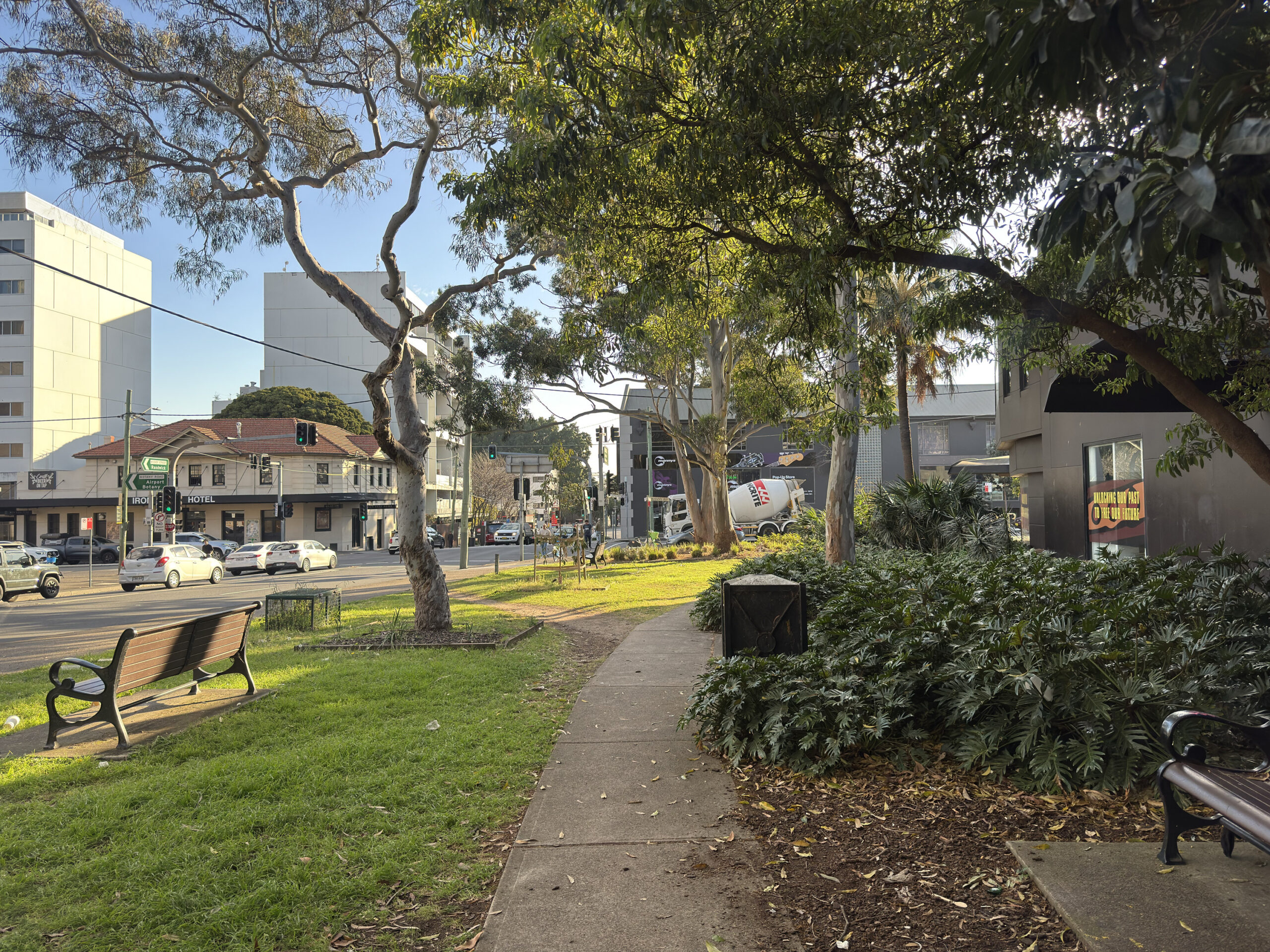
Enjoy it while it lasts. Gone by next year. Photographed 2026-09-14.
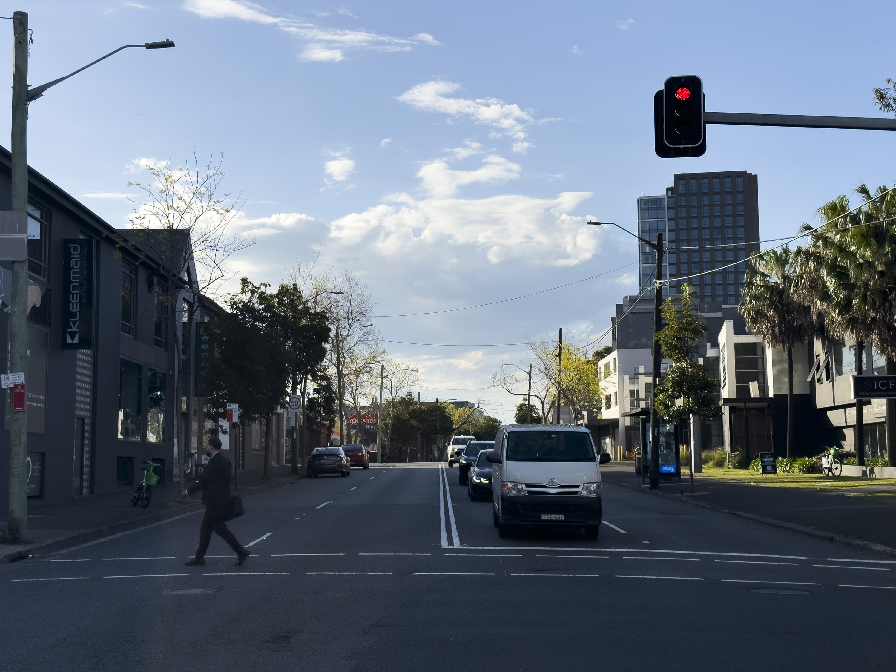
One more lane will fix it. Looking north along Botany Road at McEvoy Street. Photographed 2026-09-14.
Notes
- ↑ Or 6 days ago to select folks[1], perhaps with a mailing list created 2026-07-27T16:29:55+10:00 and updated 2026-09-08T10:14:54+10:00.[2]
- ↑ Perhaps you wonder what drives someone to write 13,000 words about this seemingly long-dead adjacent road project? You’re not the first.[6] It’s too good to print – yet.
- ↑ To save motorists a potential 8 seconds in the AM peak[9]: 83, 84 , according to the modelling.
- ↑ And for a northbound bus lane, good thing we widened a 50km/h inner-Sydney slip lane[10][11] – at St Paul’s Place right between two of Australia’s busiest train stations – “Making a bad road more awful” (Bicycle NSW). Ostensibly, one of the two project goals was “improving safety”. I trust that is true, DORAS & M&P policies were followed, and physical and temporal road user space is being prioritised for public and active transport before private vehicles – on a 2-star AusRAP road. I’m not aware of any community consultation: the community notice was published up to 12 days before construction – if one searches for TfNSW community notices on New Years Day.
- ↑ May reduce pressure? Get out of here! Who does TfNSW think they’re fooling here, advocates figured out this line decades ago.
“Improving the Botany Road and McEvoy Street intersection may also reduce pressure along alternative routes such as Henderson Road and Mitchell Road by providing a more efficient connection for drivers travelling through the area.”[3] - ↑ I’ve dropped $441 on a GIPA before, and I’ll … do it again![18]
- ↑ Keen readers will also note this covered a “Road Network Performance Review Plan” including “Euston Road, between Sydney Park Road and Botany Road” (E40 B iii)[20] – did anyone spot how quietly that[21] was uploaded? With “review date” 2025-10, doc 2026-06, (per sitemap.xml?page=1) 2026-07-08, TfNSW page updated 2026-02 – what am I supposed to make of that? Good thing Parramatta Road doesn’t need bus lanes apparently.[21]: p. 81 (PDF 91) Has John Graham been ignored: does this read like property acquisition is still on the cards? “Property acquisition … could increase cost, delivery timeframes and viability for some projects.”[21]: p. 129 (PDF 143) Almost as impressive is the robots meta content including noindex, nofollow, noarchive, nosnippet, noimageindex on the page linking to the Rozelle Interchange and Western Harbour Tunnel Enabling Works Design and Construction Deed[22], dated 24 November 2023[22]: PDF 4 , created in 2024 (according to the file metadata) and published about two weeks ago.[23][24]
- ↑ “funded outside the $16.812 billion budget” for WestConnex with the removal from the budget not “supported by robust analysis and justification”[25]: 2 (PDF 6)
- ↑ It’s a miracle Green Square turned out how it is.[27]: pp. 31-33 [28][29][30]
- ↑ “We investigated alternatives to a right turn ban from McEvoy Street into Botany Road including providing a dedicated right turn lane. This option required significant private property acquisition as well as impacts to trees and parking and was not progressed.”[3]: §Right turn removal
- ↑ And amusingly, impacts on car parking[3]: §Right turn removal like elsewhere: 10k homes to 34 stories, but apparently removing a few car parks is just too hard![32]: p. 30 [33]: pp. 6,67 Someone else must have written “…the provision of homes in Edgecliff and Woollahra results in a net reduction in vehicle kilometres travelled by car across the GMA, when compared to a base case where this growth might have taken place in locations further away from public transport and amenities. This is illustrative of the potential benefits of transport oriented development as opposed to ‘organic’ growth in areas less well served by existing public transport and amenities.“[32]: p. 97
- ↑ “…high capacity limited access route would cause severe severance effects in the community and in particular would affect the Aboriginal housing area in Chippendale as a result of the need to cross the railway on a new alignment”[34]: p. 107
- ↑ Still not as mythical[60] as the PBN! Transport for NSW applied for privilege on 15 documents[61][62] (under SO52(5) at the time[63]). 24 non-privileged spreadsheets[64] and 638 non-privileged documents were released and are accessible to the public.[65] The Parliament of NSW website index you have likely already read, dear eagle-eyed reader, omits these 638 documents. Let historians note one version of the Non-privileged – Excel document[65] states 25 items but actually has 24 rows: row with count 21 is skipped.
Perhaps TfNSW could just give Bicycle NSW the PBN geospatial files[60] and save me the effort of trawling through 2356 pages of internal emails and documents? I’ve got better things to do. - ↑ It’s uncanny how well the 1961 DLC report predicted the location of the Rozelle interchange.[66]: Plate 16
- ↑ “The DMR has a long memory and has at last talked the government around to the plans it has always had its heart set on” – Stephen Harris, Senior Lecturer in Town Planning, UNSW, 1986.[67]
- ↑ Or worse, ask volunteers to tell them to follow their own strategy: “…when a government agency writes 100 pages “discussing” a problem its own existing policy already solved on paper three years ago, is that a discussion — or a very long way of not implementing something?””[70]
- ↑ “While we understand this change may result in reduced connectivity for some road users, it will reduce congestion and queuing through the intersection and improve travel time reliability for all road users. Improving the Botany Road and McEvoy Street intersection may also reduce pressure along alternative routes such as Henderson Road and Mitchell Road by providing a more efficient connection for drivers travelling through the area.”[3]: §Right turn removal
- ↑ At least the dollars come with a bus lane, unlike Fifteenth Avenue.[74]
References
- ↑ “Botany Road”. yoursay.transport.nsw.gov.au. Transport for NSW. 2026-09-09.
Page published: 09 Sep 2026, 12:46 PM
- ↑ Source of https://yoursay.transport.nsw.gov.au/botany-bus-improvements/surveys/botanyroad_subscribe1
- ↑ 3.0 3.1 3.2 3.3 3.4 3.5 3.6 3.7 3.8 “Botany Road and McEvoy Street intersection and bus corridor improvements”. Transport for NSW. 2026-09-14. Archived from the original on 2026-09-14. Retrieved 2026-09-14.
- ↑ 4.0 4.1 “botany-rd-and-mcevoy-st-map.jpeg”. Transport for NSW. Archived from the original on 2026-09-14.
- ↑ Rod Fraser (1964). Examination of Aspects of Metropolitan Planning Significance in the De Leuw Cather Company’s Report on Geometric Design Study. Sydney Urban Expressways (Report). Sydney: Cumberland County Council.
David Ball (February 1996). “The Road to Nowhere? Urban Freeway Planning in Sydney to 1977 and in the Present Day (Urban Research Program Working Paper No.51)”. p. 16. Archived from the original on 2026-03-02.
Nick Yetzotis (2026-05-12). “Notice of decision on your access application under the Government Information (Public Access) Act 2009 (GIPA Act)”. Letter to Jake Coppinger. 26T-1774. - ↑ hornetfig (2026-02-05). “Untitled r/sydney comment”. Reddit.
Why it has a 12,000 word Wikipedia article started only last year, written effectively by one author – the blog author and linked to only in the Sydney roads infoblock is a ~mystery~.
- ↑ “Harris Street pedestrian crossing removal” (PDF). Transport for NSW. November 2023. Archived (PDF) from the original on 2025-09-25.
- ↑ “Road network upgrades to boost safety for Western Distributor”. Transport for NSW. 2022-09-21. Archived from the original on 2022-09-30.
- ↑ “Western Distributor Network Improvements Review of Environmental Factors” (PDF). Transport for NSW.
- ↑ “Community Notice: Intersection Improvements at Regent Street and Cleveland Street, Chippendale from Monday 13 January” (PDF). Transport for NSW. January 2025. Archived (PDF) from the original on 2025-11-17.
- ↑ “(Untitled Facebook Post)”. BikeSydney. 2025-05-28. Archived from the original on 2025-09-03.
- ↑ Daniel Lo Surdo (2025-09-22). “Former transport minister was misled over ‘massive’ safety promise, secret emails reveal”. The Sydney Morning Herald.
- ↑ Jake Coppinger (2025-05-27). “Not enough funding for Sydney Park Junction – Addendum REF to cut scope”.
- ↑ Jake Coppinger (2024-09-09). “Another broken WestConnex promise: secret Sydney Park Junction design changes”.
- ↑ Jake Coppinger (2024-11-26). “Sydney Park Junction: TfNSW Won’t Commit to Original Scope Despite Ministerial Intervention”.
- ↑ Daniel Lo Surdo (2025-05-27). “The transport minister made a safety promise. Four days later, it was torn apart”. The Sydney Morning Herald.
- ↑ “Government Information (Public Access) Act 2009”. Transport for NSW. n.d.
- ↑ Jake Coppinger (2025-09-24). “Green Lights More Often: The Secret 2018 Study of Sydney’s Traffic Signals”.
- ↑ 19.0 19.1 Jacobs Group; Roads & Maritime Services (November 2019). Alexandria to Moore Park Project Stage 1 Review of Environmental Factors (PDF) (Report). Transport for NSW. ISBN 978-1-922338-18-1. Archived (PDF) from the original on 2025-10-14.
- ↑ Roads and Maritime Services (2018-08-20). “WestConnex M8 (New M5) Conditions of Approval – WestConnex Stage 2 – New M5 SSI 6788” (PDF). Linkt. p. 69.
- ↑ 21.0 21.1 21.2 M4 East 5 Year Road Network Performance Review Plan (PDF) (Report). Transport for NSW. June 2026.
- ↑ 22.0 22.1 “Rozelle Interchange and Western Harbour Tunnel Enabling Works Design and Construction Deed Second Deed of Amendment” (PDF). 2023-11-24. AUS\TCZ\692423830.19. Archived (PDF) from the original on 2026-09-09. “Government Information (Public Access) Act 2009 Explanatory Table Rozelle Interchange and Western Harbour Tunnel Enabling Works Design and Construction Deed Second Deed of Amendment” (PDF). transport.nsw.gov.au. n.d. 692811057.06.
- ↑ “Rozelle Interchange and Western Harbour Tunnel Enabling Works Design and Construction Deed Second Deed of Amendment”. transport.nsw.gov.au. Transport for NSW. 2026-09-01. Archived from the original on 2026-09-09.
- ↑ “sitemap.xml?page=6”. transport.nsw.gov.au. Transport for NSW. 2026-09-01. Archived from the original on 2026-09-09. Retrieved 2026-09-09. (2026-09-01T17:39:56+10:00)
- ↑ 25.0 25.1 25.2 “WestConnex: changes since 2014” (PDF). Audit Office of NSW. 2021-06-17.
- ↑ 26.0 26.1 WestConnex: changes since 2014 (PDF) (Report). NSW Audit Office. 2021-06-17. Archived (PDF) from the original on 2026-02-11.
- ↑ “GREEN SQUARE TOWN CENTRE DRAFT MASTERPLAN AND LOCAL ENVIRONMENTAL PLAN AND RELATED MATTERS – INFORMATION REPORT” (PDF). City of Sydney. 2004-11-05. Archived (PDF) from the original on 2026-09-14.
- ↑ South Sydney City Council (2003). South Sydney Section 94 Contributions Plan 2003. The Green Square Town Centre (GSTC) Masterplan claimed the South Sydney Section 94 Contributions Plan 2003 (South Sydney Council) included $5,140,000 for such an New East-West Relief Route.
- ↑ “ITEM 7. ZETLAND AREA TRAFFIC STUDY – STATUS REPORT (2029696)” (PDF). City of Sydney. 2005-04-01. pp. 12, 14, 17. Archived (PDF) from the original on 2026-09-14.
- ↑ Maunsell Australia Pty Ltd (2003). Zetland Area Traffic Study (Report).
- ↑ “Accelerated Infrastructure Fund”. NSW Department of Planning, Housing and Infrastructure. 5 May 2025. Archived from the original on 2026-03-12. Retrieved 2026-03-12.
Improvment (sic) work at McEvoy Street and Botany Road.
- ↑ 32.0 32.1 Edgecliff-Woollahra State-led Rezoning Transport Management and Accessibility Plan (PDF) (Report). Transport for NSW. August 2026.
- ↑ Strategic Cycleway Corridor Program Eastern Harbour City (Report). Transport for NSW.
- ↑ 34.0 34.1 MacDonald Wagner (February 1987). Pyrmont-Alexandria Traffic Management Proposal – Environmental Impact Statement. ISBN 0730545490.
- ↑ The Premier; Minister for Planning and Public Spaces (2023-07-23). “NSW Government investing $40.9 million to fast-track critical infrastructure in high growth communities” (Press release). Archived from the original on 2026-01-17.
- ↑ 36.0 36.1 36.2 36.3 “WestConnex traffic ‘nightmare’ headed to Sydney’s east under the A2MP plan”. The Daily Telegraph. 2017-12-12.
- ↑ RON HOENIG. “Legislative Assembly Hansard – 16 February 2017”. Parliament of NSW.
- ↑ 38.0 38.1 Marie Hogg (2018-03-13). “Moore Park trees could face the axe for WestConnex connection”. The Daily Telegraph.
- ↑ Alex Greenwich (2018-03-07) [2017-03-06]. “Alexandria to Moore Park (Private Members’ Statement, 6 March 2017, Legislative Assembly, NSW Parliament)”.
- ↑ 40.0 40.1 Matt O’Sullivan (2016-12-06). “WestConnex spawns major upgrade to congested road corridor in inner Sydney”. The Sydney Morning Herald.
- ↑ Alex Greenwich (2016-12-07). “Alexandria to Moore Park Connectivity Upgrade” (PDF). Letter to Duncan Gay. Archived (PDF) from the original on 2024-08-12.
- ↑ Duncan Horscroft (2018-06-25). “All Roads Could Lead to Off-ramp Chaos”. The Beast. Archived from the original on 2024-07-22.
- ↑ Nigel Gladstone (2017-11-08). “Alexandria Roads a ‘cancerous mess’“. The Daily Telegraph.
- ↑ Doorknocking, 2026-09-14.
- ↑ Botany Road Project Team (2026-09-14). “Botany Road Feedback Form”. yoursay.transport.nsw.gov.au. Transport for NSW.
Hello, Submitting feedback on Transport projects helps to inform the project team of your concerns. Our engagement team will provide a summary report to inform the next stage of design, using this feedback. With this in mind, please answer the following as best you can. Kind Regards, Botany Road Project Team
- ↑ “Project finder (filter by Alexandria to Moore Park Project)”. Transport for NSW. 28 April 2017. Archived from the original on 2026-09-14. Retrieved 2026-09-14.
- ↑ Matt O’Sullivan (2019-07-08). “Sydney CBD bypass plans to be scaled back to allay residents’ concerns”. Sydney Morning Herald.
- ↑ David Levinson (2018-11-13). “Traffic connector, community disconnector: increased traffic and pedestrians don’t mix”. Foreground. Archived from the original on 12 March 2026.
- ↑ Roads & Maritime Services (December 2016). “Alexandria to Moore Park Connectivity Upgrade” (PDF). Archived (PDF) from the original on 2025-10-14.
- ↑ “Alexandria to Moore Park Connectivity Upgrade – Display of the preliminary concept design” (PDF). Roads and Maritime Services. June 2017. RMS 17.278.
- ↑ Alexandria to Moore Park Stage 1 Submissions Report (PDF) (Report). Transport for NSW. April 2020. Archived (PDF) from the original on 2025-10-14.
- ↑ Ava Tan, Connor Hoang (2025-09-24). “224-234 Young Street, Waterloo Transport Impact Assessment”. ason group. p. 10 (PDF 14). Archived from the original on 2026-09-14.
The McEvoy Street/ Bourke Street/ Lachlan Street intersection upgrade is not included as part of the Stage 1 works, with the indicative future intersection layout and road alignment shown in Figure 10. TfNSW has not provided a timeframe for the compulsory acquisition process or road widening, and alignment works.
- ↑ Matt O’Sullivan; Christopher Harris (2024-02-09). “‘We just bought the place’: Homes, businesses were slated for demolition in Parramatta Rd expansion”. The Sydney Morning Herald.
- ↑ Main Road Development Plan for Sydney Metropolis and County of Cumberland – Part 1 Investigations Relating to the Present and Future Extent and Pattern of the Metropolis. Department of Main Roads NSW. 1940.
- ↑ Department of Main Roads NSW (1976). The Roadmakers – A History of Main Roads in New South Wales (PDF). The Department. p. 204. ISBN 0-7240-0439-4. Archived from the original (PDF) on 2024-04-26.
- ↑ E. R. Jefferay (1963). PLANNING AND DESIGN OF URBAN EXPRESSWAYS IN N.S.W. WITH PARTICULAR REFERENCE TO THE COUNTY OF CUMBERLAND (Report). Department of Main Roads.
- ↑ Hon. Justice Michael Barker President, WA State Administrative Tribunal (2007-05-04). How Planning and Environmental Law Has Shaped Our Cities (PDF). 2007 Planning Institute of Australia National Congress. p. 8. Archived (PDF) from the original on 2025-04-06. Retrieved 2025-10-26.
- ↑ “RTA Heritage and Conservation Register – Thematic History – Second Edition 2006” (PDF). Roads & Traffic Authority NSW. 2006. p. 45. Archived (PDF) from the original on 2024-05-06. Retrieved 2025-10-26.
- ↑ County of Cumberland Main Road Development Map (Map). Department of Main Roads NSW. 1945.
- ↑ 60.0 60.1 Sarah Bickford (2026-08-28). “What is the Principal Bicycle Network?”. Bicycle NSW. Archived from the original on 2026-08-30. Retrieved 2026-08-30.
- ↑ “Transport for NSW – Privileged Index Principal Bike Network Plan” (PDF). n.d. “Submissions of Transport for NSW Order for papers – Principal Bike Network Plan Strategy 3 June 2020” (PDF). n.d.
- ↑ “Return to order – Principal Bike Network Plan for Sydney – Return identifying documents received on Wednesday 24 June 2020 from the Secretary of the Department of Premier and Cabinet, which are considered to be privileged and should not be made public or tabled”. parliament.nsw.gov.au. Parliament of NSW. 2020-08-04 [2020-06-24]. 1661PRIV.
- ↑ “Standing Rules and Orders of the Legislative Council” (PDF). Parliament of NSW Legislative Council. 2004-05-05. p. 15 (PDF 23). Archived from the original (PDF) on 2025-12-01.
- ↑ “Non-privileged – Excel” (PDF). files.parliament.nsw.gov.au. Parliament of NSW. n.d. (RO1660)
- ↑ 65.0 65.1 Non-privileged – Standing Order 52 – Index of Documents: Principal Bike Network. Parliament of NSW. “Return to order – Principal Bike Network Plan for Sydney – Documents received on Wednesday 24 June 2020 from the Secretary of the Department of Premier and Cabinet, together with an indexed list of documents”. 2020-08-04 [2020-06-24]. 1660RO. State Archives NSW (2020-08-04). Box NRS-18551-21-378. A000029437 (AC0892805). Western Sydney Records Centre: Museums of History NSW. State Archives NSW (2020-08-04). Box NRS-18551-21-379. A000029436 (AC0892806). Western Sydney Records Centre: Museums of History NSW.
- ↑ 66.0 66.1 De Leuw Cather (August 1961). Report on Geometric Design Study: Sydney Area Expressways.
- ↑ Stephen Harris (1986-08-17). Stop Them Resurrecting Askin’s Freeways – Background Issues and Concerns (Report). Inner Sydney Regional Transport Group. p. ii.; Stephen Harris (1986-08-17). Notes from Address. Inner Sydney Regional Transport Group Public Meeting.
- ↑ Brown, Aston; Bowring, Declan (2026-02-09). “Cyclists slam ‘nightmare’ shared path at new Sydney Fish Market”. ABC News. Archived from the original on 2026-02-08.
- ↑
Transport for NSW (October 2025). “Connecting NSW Strategy – Priorities for Transport” (PDF). New South Wales Government. p. 27. Archived (PDF) from the original on 2025-11-01. Retrieved 2025-11-02.
We will rebalance road investment, from providing additional capacity for general traffic (such as through road widening), to reallocating of existing road space for public transport and active transport alternatives. More space for buses can lead to fewer vehicles moving more people. The reallocation of road space will be required for high quality, frequent, turn-up-and-go bus services which can support the delivery of more diverse, ‘missing middle’ housing in areas closer to existing infrastructure, services and jobs.
- ↑ WalkSydney (2026-06-28). “When is a discussion paper not a discussion paper? TfNSW “Have your say on Walkable NSW by 30 June”“. Substack.
- ↑ …Congestion is best managed in our cities using other policies, such as road-user charging, and the effective provision of public transport, which also becomes cheaper at higher densities. Brendan Coates; Joey Moloney; Matthew Bowes (November 2025). “More Homes, Better Cities: Letting more people live where they want” (PDF). Grattan Institute.
- ↑ Initiatives like transit lanes, bus priority lanes, and bus rapid transit can make buses faster and more reliable, and so entice onto public transport many people who would otherwise drive. Such measures can restrict road space and risk worsening traffic for remaining cars, but they usually allow a higher total number of people to travel. “Building more homes where infrastructure costs less” (PDF). NSW Productivity Commission. August 2023. p. 28. Retrieved 2025-12-03.
- ↑ SCT Consultants (2026-07-03). Edgecliff-Woollahra Precinct State-led Rezoning Traffic and transport review – Scenario 3 (rev 1.0) (PDF) (Report). Woollahra Council. Archived from the original (PDF) on 2026-09-08.
- ↑ Aston Brown (2026-07-20). “Government urged to rethink $1.4b Western Sydney airport road upgrade”. ABC News.
- ↑ 75.0 75.1 “Submission Guide: 13,000 homes at Westmead South!”. Sydney YIMBY. 2026-09-10.
Some changes to the plan we’d love to see: (1) Active transport links: Dedicated bikeways or quietways, particularly along Hawkesbury Road, Good/Pye Street, Houison/Hassall Street, Amos Street, and Austral Avenue (as recommended by supporting studies). (2) Bus priority: Hawkesbury Road is nominated as a potential future bus corridor, however the PTS only plans for a maximum of 4 buses per hour. Dedicated bus lanes would help make the most of the public transport investment here.
- ↑ Infrastructure Australia (n.d.). “Greater Sydney cycling network improvements”. Australian Government.
Next Steps: Proponent to identify and analyse potential investment options (Stage 2 of Infrastructure Australia’s Assessment Framework). In identifying and analysing options, the proponent should continue to develop a program delivery and prioritisation approach. This should ensure there is an integrated program and pipeline of prioritised cycleways that is informed by program outcomes, land-use planning developments, demand in strategic corridors, delivery capacity and funding mechanisms.
- ↑ UrbanSpectra Pty Ltd (July 2026). Quantifying Cycling Trips in the City of Sydney (Report). City of Sydney Council.


Leave a Reply