In traffic engineering, a contraflow lane is one running in the opposite direction to the surrounding lanes. Contraflow in the context of bicycle infrastructure can either be a purpose built, separated cycleway adjacent to a one way road or the mixed use of one-way streets between bicycles and vehicle traffic.
A street is defined as ‘contraflow’ or two-way for cyclists (and in some cases pedestrians) where people on bikes (or on foot) are legally able to travel in both directions on a street designated a one-way for motor vehicles. Suitable streets typically have low traffic volumes and low speeds, with one (or no lanes) marked, sufficient width and may already be designated as a shared zone (the Australian term for a living street).
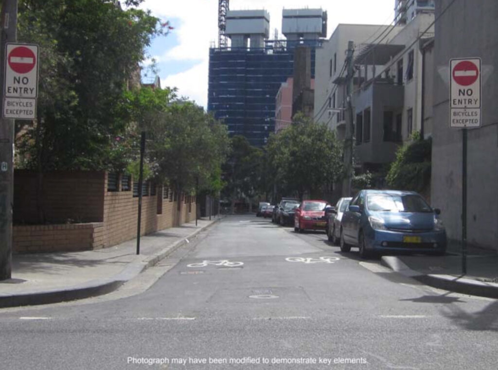
In 2014, the state agency Transport for NSW issued a technical direction permitting contraflow bicycle travel on suitable streets if approved signs and markings are allowed. When provided on suitable roads, these simple street treatments create safe new routes for cyclists with an incredible value for taxpayer funds.
The TfNSW Technical Direction (TTD 2014/002) describes contraflow cycling facilities as “a cost-effective treatment that enhances the cycling experience by improving the permeability of neighbourhoods and by reducing bicycle trip lengths”.
This is by no means an argument against more substantial investment in separated cycleways. The Queensland Government found cycling infrastructure has a 5 to 1 return on investment, and the UK Government found with beneft-to-cost ratios in the in the range of 5:1 to 19:1 – some as high as 35.5 to 1 (that is, a return on investment of up to 3550%). These benefits include improved public health, reduced emissions, reduced traffic, and reduction in expensive taxpayer funded road maintenance (road wear is proportional to the 4th power of axle weight). We can’t afford not to invest in dedicated cycling infrastructure.
New contraflow cycling in the City of Sydney
The City of Sydney has recently approved 159 suitable streets across 24 suburbs, which will greatly improve the network of legal cycling routes in inner city Sydney. The implementation will proceed as soon as budget and works capacity allows.
This blog post is a proposal of additional streets which may be suitable for basic contraflow cycling infrastructure that the council could install in future, with a focus on the utility of OpenStreetMap for researching potential streets.
What makes a safe contraflow street?
Most streets can become contraflow streets with the right infrastructure (a separated cycleway), but this blog post focuses the extremely cost efficient cases where they are feasible with only a sign and/or painted markings.
The TfNSW technical direction specifies:
Contra-flow bicycle facilities should be assessed as a potential treatment on all local low speed, low volume one-way streets, including shared zones.
Ideally, all contra-flow bicycle movements will be delineated by a bicycle lane. A bicycle lane must be installed in locations where:
• Sight distances are restricted due to bends in the road or other features.
• Motor traffic volumes or speeds present a safety risk.
• Bicycle traffic volumes or speeds present a safety risk.
• The gradient and/or other road geometry increase the risk of collisions or unsafe driving or riding behaviours.
• The number or location of driveways present a safety risk.Note: The NSW Road Rules prohibit parking in signposted bicycle lanes.
TTD 2014/002 Signposting for contra-flow bicycle facilities
If the road space is too narrow to permit a marked bicycle lane and there is good sight distance, motor traffic volumes and speeds are low and the road geometry does not present an unacceptable safety risk, the contra- flow movement can be provided by signage alone.
With this in mind, OpenStreetMap does not include traffic volumes, however by filtering out multi lane roads, roads with high speed limits and roads that are designated as important to the motorway network we can remove from our query most high volume roads and identify further potential candidates for contraflow cycling facilities.
Streets that currently allow contraflow cycling
Below is a map of current streets that permit contraflow cycling. All maps are generated just for you as you load this page – so it’s always up to date.
I make use of open source OpenStreetMap (OSM) data which is a rich data source of cycling and road infrastructure. OSM is collaborative – if you notice any errors you can edit the map, and they will show up here. The dataset is heavily used (and improved) by commercial entities including Facebook, Amazon, Microsoft, TomTom, Uber, Strava, Citymapper and government entities such as the Transport for NSW Trip Planner and the Victorian Department of Transport and Planning (who recently made the strategic decision to use OSM as their foundational mapping data source).
A technical note: these maps are using Overpass Ultra – a brilliant, open source, vector map powered OpenStreetMap query engine by Daniel Schep (on Mastodon), inspired by Overpass Turbo. Overpass Turbo shows dots for small details by default which are not possible to disable in a shared map.
You can click on highlighted streets to view more data, such as:
- name
- lane count
- road classification
- whether it’s a shared zone / living street
(note: some of the map embeds are currently broken, please follow the “View/edit query” links)
Previously approved but not yet built contraflow streets
Below is a map of streets where the contraflow infrastructure (signs and/or road markings) is approved but under construction, or not yet built (previously approved). I have mapped them on OSM with oneway:bicycle=construction.
Potential future contraflow streets
Below is an automated query of streets that are potential contraflow street candidates. As the data is automated there may be streets not suitable, such as circular one-way service roads. The intention of this queried data is to provide a helpful starting point, from which to filter for potential candidates, through use of the easily accessible, open source data. You can run the query yourself here and modify it if desired. See the wiki for the available OSM tags relevant to bicycles to filter by.
You can read the full query on which roads are shown in the appendix below.
A proposal of streets that may be suitable contraflow streets
These are a non-exhaustive manual selection of streets from the above query (in no particular order). Some I have taken width measurements using Lidar on an iPhone.
I’ve excluded lanes that appear to be very narrow and lanes where an alternative is very close (eg. William Ln & Corfu St).
There may be errors or other reasons they aren’t suitable – any feedback or corrections is welcome in the comments below!
| Street | Suburb | Road width if known | Notes |
| Terry Street | Surry Hills | 4.61m | – Laneway behind Metro Woolworths near central – Would provide access from south Surry Hills to the Belmore Park cycleway (and further north into the city) – Already marked as cycle route on the official City of Sydney cycling map – A proposal for a living street exists, but would provide utility in the short term |
| Sophia Street | Surry Hills | 4.9m | – Long laneway with excellent visibility – Gradient towards eastern end – No parking, a number of infrequently used driveways – Great link from Fitzroy St via Riley St to lower Surry Hills |
| Boronia Lane | Surry Hills | ? | – Already has contraflow marking for pedestrians – Though already close to Boronia Street – Excellent visibility (completely straight) |
| Lansdown Street | Surry Hills | ? | – Car parking both sides – Connects to Crown St – Excellent visibility (completely straight) |
| Richards Lane & Collins Lane | Surry Hills | Collins lane 2.25m | – Collins lane very narrow – perhaps narrow enough to ban cars – Several speed cushions – Great north/south alternative to Crown St – Richards lane very suitable, even has coffee shops |
| Collins St | Surry Hills | ? | – Shared zone connector at corner of The Clock hotel – Very wide |
| Beaconsfield Lane (north) | Beaconsfield | ? | – Contraflow approved further south – Has traffic calming |
| Wynyard Lane | Sydney | ? | – The laneway just next to Wynyard Station – Would provide a north -> south route for bikes avoiding York St, Carrington St buses and George St pedestrians |
| Mullins Street | Sydney | ? | – Shared zone, 10kmh – Has a nearby coffee shop |
| High Holborn St north of Lansdown St | Sydney | ? | – Car parking both sides, good visibility – South of Lansdown likely too narrow |
| Belvoir Street (near Elizabeth St) | Sydney | ? | – Only one lane – Car parking one side – Hill but good visibility – Good candidate for dedicated contraflow lane in future – Good route from Belvoir St west to Crown St – no curb cut at Clisdell to Devonshire St |
| Shepherd Lane | Darlington | ? | – Possibly too narrow, but good connection to WIlson St cycleway – Low traffic alternative to Ivy Street |
| Dick St | Chippendale | ? | – Continuous footpath east end – Narrow with parking but lots of no parking spaces |
| Womerah Avenue | Darlinghurst | ? | – Appears perfect but perhaps missing from previous batch |
| Bulwara Road | Ultimo | ? | – Right outside library which has bike parking – Shared zone – Where narrow there is amble space on the side to duck out (at Quarry St) |
Other notes
- Devonshire St would be very useful, but a paint & sign treatment likely not sufficient
- There are plenty of one way segments on the pedestrianised George St which would be perfect for cycling – the cycling situation on George St likely needs it’s own blog post
Appendix
More maps
Contraflow permitting streets globally
Potential future contraflow streets globally
All the Overpass queries!
Query: CSV of candidates of contraflow lanes
https://overpass-turbo.eu/s/1ytu
Note:
- See the OSM Wiki for what tags mean
- This is an automated query of open source data – there may be errors
Query: Current streets allowing bicycle contraflow
[out:json];
(
  // Relation 1251066 is COS boundary:
  // https://www.openstreetmap.org/relation/1251066
  rel(1251066);map_to_area->.region;
  way(area.region)["highway"]
  ["oneway:bicycle"="no"]->.ways;
);
.ways out geom;
Query: Streets that CoS will turn into contraflow
[out:json];
(
  // Relation 1251066 is COS boundary:
  // https://www.openstreetmap.org/relation/1251066
  rel(1251066);map_to_area->.region;
  way(area.region)["highway"]
  ["oneway:bicycle"="construction"]->.ways;
);
.ways out geom;
Query: Potential future contraflow streets
[out:json][timeout:25];
(
  // Relation 1251066 is COS boundary:
  // https://www.openstreetmap.org/relation/1251066
  rel(1251066);map_to_area->.region;

  // Select roads
  way(area.region)["highway"]

  // Only roads which are marked one way,
  // and don't allow bicycle contraflow
  ["oneway"="yes"]
  ["oneway:bicycle"!="no"]

  // Exclude already approved contraflow lanes
  ["oneway:bicycle"!="construction"]

  // Excluded roads under construction
  ["highway"!="construction"]

  // Excluded proposed roads
  ["highway"!="proposed"]

  // Exclude driveways
  ["service"!="driveway"]

  // Don't include roads that are bidirectional,
  // but are separated (and appear to be one way)
  ["dual_carriageway"!="yes"]

  // Don't include if a cycleway is already mapped as separate
  ["cycleway"!="separate"]
  ["cycleway:left"!="separate"]
  ["cycleway:right"!="separate"]

  // Don't include if a cycleway already present
  ["highway"!="cycleway"]

  // If a road is customers only it's likely
  // in a parking lot
  ["access"!="customers"]

  // Don't include roads where public access not allowed
  ["access"!="no"]

  // Don't include link roads (on ramps/slip roads)
  ["highway"!="motorway_link"]
  ["highway"!="primary_link"]
  ["highway"!="secondary_link"]
  ["highway"!="tertiary_link"]

  // Don't include major roads
  ["highway"!="primary"]
  ["highway"!="secondary"]


  ["lanes"!=2]
  ["lanes"!=3]
  ["lanes"!=4]
  ["lanes"!=5]
  ["lanes"!=6]

  ["access"!="private"]

  // Don't consider parking isles
  ["service"!="parking_aisle"]


  ->.ways;
);

.ways out geom;
Query: All streets with bicycle contraflow allowed, including outside City of Sydney council
[out:json][timeout:25];
(
  way["highway"]

  ["oneway:bicycle"="no"]

  ({{bbox}});
);
out body;
>;
out skel qt;
Other useful data
Ethan’s Sydney Bike Map
One of the best OpenStreetMap powered maps of cycling infrastrure, including proposed and under construction paths: https://sydneybikemap.ethan.link/
Possible further work
- Categorising sightlines of road segments computationally to narrow down the list of possible candidates
- Creating an Overpass Turbo query of manual candidates
Leave a Reply