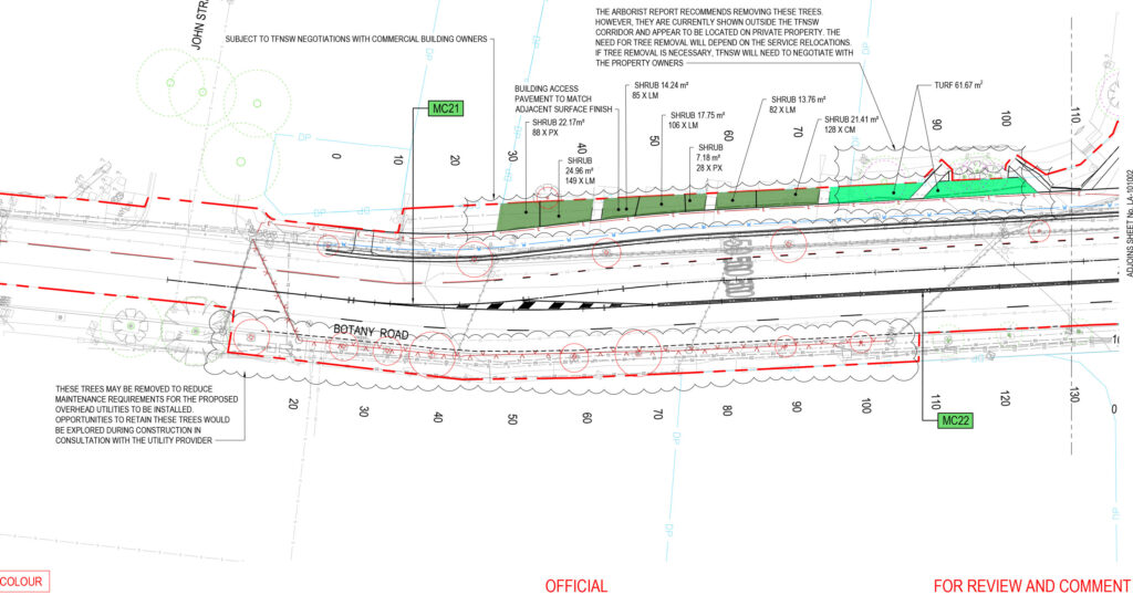
On Tuesday last week, Transport for NSW (TfNSW) closed feedback[1] on the Botany Road and McEvoy Street intersection upgrade, a multi-million dollar project to widen an inner-Sydney 4-lane road, just 400 metres from the Waterloo Metro station[a]. With transit-washing features like a bus lane away from the CBD during morning peak hour, perhaps your read about it in the Declan Bowring’s ABC article this morning[3] – with some cracking quotes from Eamon Waterford, Jamie van Geldermalsen (WalkSydney), Jennifer Kent, and Clover Moore: “It’s so disappointing the government is pursuing a road-widening project under the guise of bus improvement.” Botany Road needs bus lanes on both sides – without widening the road.
If you made one of perhaps ~127 submissions[4]: view-source: line 382 col 141050 to oppose this WestConnex zombie project[5], desecrating every Government policy you can point at, you’ll know you weren’t asked about trees. That’s because TfNSW appears to have deleted the question “I’m worried about tree impacts” less than 2 weeks before the form launched.[1]: props.pageProps.initialState.survey.surveyPage[9] It seems like TfNSW is worried about tree impacts too.
But the 9 trees – and additional 7 TfNSW murmured “may be trimmed”[6] but really “may require pruning or removal“[7]: p.38 – are the least of this project’s problems. While TfNSW promised your feedback would “inform the next stage of design”[1] the “100% DETAILED DESIGN” plans were actually issued over 9 months ago[7]: PDF pp. 216-258 and the detailed design contract ended 2 days after the end of the (publicly known) feedback period.[8]: web So much for TfNSW[9] (or Austroads[10]) consultation policy: not a single member of the public made a submission with a complete understanding of the project.[b]
So, dear reader – to inform your much needed submission to the Minister for Roads Jenny Aitchison and “share all relevant information to help the community’s understanding”[9] – given TfNSW GIPA staff previously described me as a “community advocate regarding the transport network” who has “contributed towards community consultation on issues of importance to members of the public”[11] – here’s an in depth analysis of the 258 pages of unpublished documents.[12] Read on to understand how TfNSW will try to rationalise this project in their upcoming Review of Environmental Factors “still being finalised”.[13]
This is a project that Deanne Forrest told a conference in July would go to market by Q3 of calendar year 2026[14], of which a February NSW Government report claimed “completion expected in 2026”[15], that NSW Government Planning currently claims is already under construction[16], that DPHI would waste millions on because someone is absurdly pretending it supports 10,000 homes which is 600 more[17] than the current ‘Woollahra train station rezoning’, which drew the uncharacteristically blistering attack “I am concerned the Network Operations Team responsible for this project appear to be operating in isolation from broader State Government objectives” from Clover Moore, and which has modelling predicting the road-widening “component” “impact” makes congestion worse.[c] Modelling documents detailing this must be in the public interest. TfNSW should have published it before asking what you thought – even the Epping Bridge consultation included the modelling.[18][d]
I’m not surprised they wanted to keep this modelling a secret. It predicts-and-provides more space for cars, with traffic survey data for this intersection taken before the Metro was even open.[12]: p.19 (PDF 25) In case you weren’t already aware, Network Operations have unchecked power over every traffic signal approval and every traffic signal timing in the state.[e]
Much like the partly-dead[23][f] Western Distributor (WD) vehicle capacity upgrade and the TfNSW Pyrmont-Ultimo Transport Plan – at “cross purposes”[28] to each other – “Transport for NSW is at odds with its own vision”. Bicycle NSW wrote about that WD project that “There’s a fundamental disconnect inside Transport for NSW … However, a powerful but fossilised group continues with the car-first mantra.”[29] If you accidentally subscribed to the feedback form twice, even the message you see is “it appears you have already subscribed. Contact [email protected] if there are any issues.”[30] (per the public source code).
In the mighty ABC-printed words of a previous Minister for Planning, Minister for Transport and Roads, and Minister for Infrastructure – there are “two clans” in TfNSW, one “very people-focused, then there were those who were almost vehicle-focused”.[31] This project is as “vehicle-focused” as you get, with a side of transit-washing. The other quotes by this Minister were even more concerning. To be extremely clear, I’m making no suggestion of corruption regarding this project or any individuals involved. $20m is crumbs against “$62.3 billion for roads” over the next 4 years.[32]: 2:38 [g]
Go to drinks with any transport professionals (or enthusiasts) in Sydney, and it’s a matter of time until you hear a variation of ‘we just need to wait for these dinosaurs to retire’[h]. Waiting is not a strategy – we have waited an awfully long time: “Many senior officers are due to retire within the next 18 months and it is possible that things might then change for the better.” (~1971, papers of George Clarke, re. the DMR).
Less than a year ago, the Herald reported nearly half of TfNSW staff are reluctant to speak up about tough issues, which may “range from alleged corruption or malpractice to workplace matters”. More than three-fifths of staff felt burnt out.[33] There are so many dedicated staff in TfNSW, who do their best to implement excellent TfNSW policy, while navigating layoff after layoff and reorg after reorg – in workplace conditions that have landed even the most battle-hardened engineers on mental healthcare leave – who deserve so much better than this. TfNSW staff deliver world-class stuff when given the resources and institutional support of their leaders.
Professional engineers, heed Murray: “If something does not seem right, speak up”.[32] Every “city agency has its malcontents and its idealists and its malcontent-idealists”.[34]: p.1582 If things are not improving – get your tips safely[35] to the ABC or Aston Brown, who prints bangers like “You’ve got very powerful roads bureaucrats inside Transport for NSW that think big roads are the solution to every problem” (from staff who have spent over two decades inside the beast… and years at Transurban), and “In an internal email from January 2025, obtained under freedom of information laws, a traffic management director at Transport for NSW, Shane Schneider, said the department was not acting on any request for a 30km/h zone in Sydney’s CBD because of the government’s opposition to reducing speeds.” in The Guardian.[36] I hope it’s clear I have adherence to good policy and the public interest at heart.
It’s time to let the Minister know what you think.
Thank you to Eamon Waterford, Jamie van Geldermalsen and Jennifer Kent for your comments on this project in the ABC.[3] Thank you Better Streets[37], WalkSydney[38], No WestConnex (NoWPT)[39], Alexandria Residents’ Action Group[40], Friends of Erskineville[41] for campaigning against this, including folks across transit advocacy and housing supply side reform circles – who recognise road widening for cars is a terrible way to support more density. For anyone with a platform – nsw.gov.au/nsw-government/ministers/minister-for-roads-regional-transport is the call to action. Even a sentence or two is enough.
Can’t be bothered to read this post? I get it, the length is nuts. Treat the table of contents as the article, and click through if you want. I wrote this whole thing, unpaid, at reputational risk, and don’t even live near the proposal – because it’s important and advocates (and staff) are sick of this pattern from TfNSW. Any errors are my own, and this was hastily assembled to inform you – please email me if you spot any errors (and don’t be surprised if this page changes). Policy analysts, journalists, and search engines – this one’s for you.
Overview: how did we get here, and how does this modelling work?
As I detailed in my opening-shot 3 weeks ago (Just one more lane: TfNSW revives WestConnex zombie Alexandria to Moore Park road project) TfNSW have been thinking about this road widening for a very long time – since they were the DMR. It’s the intersection of both the Southern Arterial Route (~13,000 words, 168 references) and the Alexandria to Moore Park Project (~3,500 words, 80 references).
And this TfNSW-proposed project is a shocker. The project page says the bus lane is AM only because it was found to have “lower impacts on the wider road network than would occur in the afternoon peak”. Wouldn’t want to bother some private cars with a bus lane!
TfNSW requested ‘feedback’ for two weeks, with zero documents to rationalise it, saying the feedback would inform designs while modelling and detailed plans were finished months beforehand. It was clear some modelling must exist, given phrases like “57 vehicles would be spread across the alternative routes during the AM peak hour…”.[6] Eventually Clover published a letter naming a Transport Impact Assessment (TIA)[42] and off went my GIPA.
This post has as much as I could figure out from these documents[7] before the ‘new’, non-public, consultation end date of Friday 9 October.[13] You will also notice a terrific ABC article by Declan Bowring, published this morning.
What’s wrong with this modelling?
What is a Transport Impact Assessment (TIA), and why is this one no good? If you own land and want to build something big that might affect others, you have to file a Development Application (DA), and sometimes look at how it might affect nearby traffic patterns (the Impact). This TIA is to assess the government’s own proposal, to analyse the impacts of a transport infrastructure proposal. It’s important to remember the study does not propose the changes so is limited in suggesting alternatives; additionally the nature of a TfNSW-commissioned study to approve its own work comes with other hazards of course.
This TIA appears to have been started a while ago, before the Waterloo Metro opened, with haphazard dates on which traffic was surveyed between 2022 and 2025. Perhaps because it began some time ago, it uses an outdated TfNSW traffic forecasting model (STMv3.91 using TZP22), and the project doesn’t meet current TfNSW policy at all.
There are some concerning features of the modelling. In cases where future traffic volumes are negative (predicted to drop), it sets these growth rates to 0% – to take “a conservative approach” – where “conservative” means more likely to support the road widening.
It does some strange maths – like taking the number of cars at intersections from before the metro opened, taking TfNSW’s (outdated) yearly forecasts of increased car volumes, and apparently multiplying to arrive at how many cars will arrive at each intersection 10 years in the future. The dates are hard to keep track of – TZP22 data for growth factors “estimated by taking the difference between the 2021 and 2041 forecast years” (20 years), then 10-year and annual average growth percentages “vs. base” reported (and anything negative becomes 0). But some intersections have a 2021 base scenario, some have a 2022 one, and some have the May 2024 physical layout.[4]: 20 Remember we’re in 2026 and if it gets built in 2027, that means we’d be (2027-2022)/10 = 5 years into the estimated 10 year growth rates – and chances are that hasn’t actually happened.
Why not one more lane?
The ‘just one more lane‘ mentality often parodied, and for good reason. It’s called “predict-and-provide” transport modelling, and the path is such a well-trodden fallacy that NSW Government policy doesn’t allow it. Assume vehicle numbers will go up to argue more road capacity is needed, build more road capacity, then lo and behold – the predictions come true.
But when you don’t build, as Clover’s letter pointed out regarding the predictions of WestConnex-caused carmageddon[42], the predictions don’t come true – forgetting for a minute the foregone conclusion of why build a road… if it requires you to build another one to fix it. There are software packages in which you punch in such demand numbers and out comes a letter ranking – like a school report card – the weaponised technocratic method to argue something must be done. How could one argue against a calculator, especially when the numbers are secret – and better things to do with your time like me writing this page?
But like predicting growth rates of water flow, and the nature of water filling a pipe – filling a road to more than 100% capacity just is not possible (or more precisely, queues form and downstream intersections have lower demands). This is the sleight of hand of modelling road intersections independently – if one upstream intersection output limits the input of another intersection, the model wouldn’t know. Enough constrained inputs – and you end up with the Sydney CBD. You can’t have too much traffic if you can’t get a car in to cause it, and to state the not-obvious-enough: it’s challenging to get too much traffic on a bus lane (or two if necessary), and… you can’t have too much car traffic on our pedestrianised George Street.
Streets, and transportation, are for people
The problem with dismally predicting the future is forgetting our streets are malleable, and our government is elected with agency. In the clearest case, the predicted 255 cars/hour on Raglan Street between 8:45am-9:45am would be impossible in 2032 if we closed the road to cars! This is exactly what we now know TfNSW requested on Raglan Street just months ago, but was not popular.[43] Closing McEvoy and Botany is obviously extreme – but there’s no reason we can’t have a 24-hour bus lane along them both (TfNSW could always explain why they couldn’t). We must not forget the goal of big transport projects is not to move as many cars as possible, it’s to move people. Movement for the sake of it isn’t always necessary: there’s no need to decentralise Sisyphus down the hill and spend billions on wider roads (or high speed rail) to roll it back up, a downstairs coffee shop in an apartment only creates elevator traffic, and just existing on George Street or Strøget is a wonderful way to spend an afternoon.
Seeking feedback from the community without telling them enough about a project isn’t just rude, it’s against policy. This project’s modelling – let alone the existence of it – wasn’t made available to the public. Neither was the fact that a Review of Environmental Factors (REF) is being prepared. How the TIA and REF interact is anyone’s guess. Perhaps we should be grateful the public was asked for feedback at all.
Personally, I don’t want to be consulted only for TfNSW to ignore me – I want TfNSW to follow their own damn (good) policy. More consultation isn’t the solution here. This is why policy exists – for it to be followed when we’ve collectively agreed beforehand what needs to be done.
This long document outlines why it misses the mark. If it feels like you’ve read it all before, you have. I’m getting tired of it – and others have been repeating these points for a lifetime before I started.
Issues with the proposed project or modelling
The place of a TIA is stated earlier – this is an external analysis of a TfNSW proposal, so likely has limited range to suggest alternatives.
The TfNSW proposal is not in line with TfNSW policies
The proposal is inconsistent with a range of NSW Government policies and strategy objectives that seek to reduce car dependence, increase walking, cycling and public transport, create safer and more attractive places, and support sustainable urban growth.[42]
In the current TfNSW Connecting NSW strategy[44], one of the 6 priorities is “Reimagine road space to drive model shift”. It states:
In the past we have invested in additional capacity. While this approach can provide short-term relief, in the absence of providing attractive alternatives to driving, we often see the congestion return. We need to reimagine how we think about and use road space.[44]: p.26
Most critically, it states (emphasis mine):
We will rebalance road investment, from providing additional capacity for general traffic (such as through road widening), to reallocating of existing road space for public transport and active transport alternatives. More space for buses can lead to fewer vehicles moving more people.
The reallocation of road space will be required for high quality, frequent, turn-up-and-go bus services which can support the delivery of more diverse, ‘missing middle’ housing in areas closer to existing infrastructure, services and jobs.[44]: p.27
How does the TIA respond to this priority “Reimagine road space to drive mode shift”? It doesn’t – it only claims to address “Restore reliability and build resilience”:
The proposed bus lane is expected to increase bus reliability and is aligned with the priority “restore reliability and build confidence”.[12]: p.12
It then responds to this with “The proposed bus lane is expected to increase bus reliability and is aligned with the priority “restore reliability and build confidence”.”[12]: p.12 I think it’s quite clear the right turn ban has very little to do with bus priority measures.
The South East Sydney Transport Strategy (Transport, 2020) “envisions that “People travelling to, from and within South East Sydney choose walking, cycling and public transport” and identifies rapid bus infrastructure on Botany Road as part of its desired transport future.”[12]: p.12 [i]
The TIA finds TfNSW’s proposal does not consider or prioritise people walking or cycling first
The Existing performance and operations section assesses “Vehicle delay and intersection capacity”, “Bus on-time running” and “Road user safety”.[12]: p.12 Performance of the intersection for people walking or cycling is not assessed.[12]: p.12
Walking space on every single footpath adjacent to traffic on Botany Road and McEvoy Street is at Walking space LOS F – the lowest possible rating, even while “disregarding frequent obstacles such as street trees, lighting poles, bus stops, rubbish bins, and other utilities”.[12]: p.7
The signal wait times aren’t much better: even though “controlled crossings are spaced closely on McEvoy Street”, the “long traffic signal cycles yield a rating of D for the Austroads pedestrian crossing delay or detour level of service on the two blocks of McEvoy Street adjacent to Site 3” (Botany Road / McEvoy Street, aka TCS 45, 1940-11-25).[12]: p.8 On Botany Road the “Controlled crossings are spaced far apart”, resulting in a rating of “LOS E- for crossing delay or detour”.[12]: p.8
Cycling isn’t any better: “Dedicated cycling infrastructure is not provided on either Botany Road or McEvoy Street”.[12]: p.9 The TIA does appear to recognise the existing footpaths are too narrow to safely be designated as shared paths:
Cycling is not permitted on the adjoining footpaths for people over the age of 15 and should not be permitted within the existing road space allocation as the adjoining road related areas are not consistently wider than four metres, the minimum width for a shared path stipulated by Transport’s Cycleway Design Toolbox.[12]: p.9
The TIA finds TfNSW may be overstating project safety benefits
Of the four proposed changes, the TIA identifies two are likely to modify crash risk[12]: p.65 (PDF 71) ; there are 5 mechanisms within these two changes[12]: p.65 (PDF 71) , and only 1 of the 5 conditions is included in the Austroads Road Safety Engineering Risk Assessment Part 6: Crash Reduction Factors (AP-T151-10).[12]: p.65 (PDF 71)
The Austroads’ Road Safety Engineering Risk Assessment Part 6: Crash Reduction Factors (AP-T151-10), where adding a right-turn lane is described as “intersection – right turn lane”, estimates a reduction in crashes by 30-35% in an urban signalised intersection, but confidence in this estimate is low.[12]: p.65 (PDF 71)
The TIA notes evidence from North America reports of a statistically significant association between increased crossing distance and increased pedestrian casualty risk after controlling for pedestrian and vehicle volumes.[46]
The TIA notes that superseded RTA guidance[47] states that fully protected right turns are likely to significantly reduce crashes between opposing vehicles turning and marginally reduce crashes with people walking. The TIA finds:
However, the more recent Austroads guidance does not adopt these estimates as the evidence for these estimates (which is not presented in the superseded RTA guidance) is not strong enough to quantify their effect based on crash type.[12]: p.65 (PDF 71)
It then concludes:
In sum, there is not enough scientific evidence to confidently quantify the expected impact of the Proposal on crash risk at the site. It is probable that the Proposal will reduce the risk of vehicle-vehicle crashes by some degree, but it is unclear what impact the Proposal will have on the safety of people walking, who are currently the only road user type represented in trauma at Site 3.[12]: p.65 (PDF 71)
I expect TfNSW may call on the Pedestrian Protection Program (PPP) findings to draw safety conclusions.[48][49][50][51], with statistical analysis by Monash University[52]
I am not aware of any substantive critique of this analysis – but the analysis did find at some intersections:
Further, it was revealed that delay treatments are more effective than adding arrows to control traffic movements. This is a positive finding given that changing the signal phasing to provide a timed delay for pedestrians to cross is easier to implement and less costly than changing the infrastructure to add turn arrows.
The project is not aligned with City of Sydney policy
The proposal is inconsistent with City of Sydney policies and strategy objectives that seek to reduce car dependence, increase walking, cycling and public transport, create safer and more attractive places, and support sustainable urban growth.[42]
While the project includes a southbound, away-from-city, AM-peak bus lane and road widening, it could narrowly be interpreted as aligned with the City’s strategy to Reallocate Street Space[12]: p.6 (PDF 12) :
The Access Strategy and Action Plan Continuing the Vision (CoS, 2023) explains the City of Sydney’s approach and commitments to managing access and transport to support environmental, social and economic outcomes.
The proposed bus lane is aligned with Strategy B Reallocate Street Space, a principle of which is to reallocate street space to space-efficient users including public transport.[12]: p.6 (PDF 12)
To be clear, Strategy B: Reallocate street space in the Access Strategy includes in principle B1 “We will work to provide street space for the most economically important and space-efficient users, especially people walking, cycling and on public transport.”[53]: p.17
In a cruel twist, the City’s Access Strategy republishes a map from Transport’s 2021 Tech Central Place-Based Transport Strategy[54][j] – labelling Botany Road with “Time-sensitive opportunities to reallocate road space”, specifically “2026 (post opening of Western Harbour Tunnel)”.[54]: p.29 [53]: p.18 [k]
Adding McEvoy St turn bans to increase private vehicle capacity along a road without a single bus route, and widening a road – then adding a bus lane away from the city during morning peak hour – is not reallocation!
The traffic forecasting model doesn’t even include local streets, for diverted cars
The Traffic Forecasting Model (STFM) used (STMv3.91, TZP22) does not include local roads. Local government is responsible for around 90% of the NSW road network by length.[55] The TIA predicted redistribution of trips from arterial roads to local roads. “more localised trips which may not be fully represented in STFM due to the simplified network representation.”[12]: p.44
To address this concern, the TIA recommends local roads are studied by TfNSW before the project is initiated, and monitored for impacts.[12]: p.63 I fear such impacts might be interpreted like Sydney Metro C&SW CoA D12[56] (and perhaps around every Metro West station captured by CoA E126 and E124) as ‘measuring and preserving the Level of Service. We know what sort of projects that leads to – you’re reading about it now.
The project does not even consider implementing safer speeds, with clear safety evidence
More broadly, cities which have achieved Vision Zero[57][58] do not seek to maximise private vehicle road capacity by implementing turn bans and such, but – in the words of previous NSW Road Transport Minister Andrew Constance in a 2019 Norway visit – approached road safety in a “very different way”.[57]: web
There is excruciatingly clear evidence that reducing urban speed limits increases road safety, among many other benefits. I note that:
- the current speed limit is 50 km/h
- The Alexandria to Moore Park project proposed to increase speed limits to 60 km/h.[59]
- In August 2018, the City of Sydney was urging the state government to implement a 40 km/h speed limit across the A2MP project.[60]
- TfNSW stated in April 2020 they would initiate a review to reduce the speed limit to 40 km/h after the opening of the New M5 and St Peters Interchange (WestConnex) “to support the government’s commitment to Vision Zero.”[61]: 47 (PDF 56) – yet the WestConnex M8 opened in July 2020.[62]
- the speed limit changes in November 2024 that included “St Peters and Alexandria” excluded the state roads making up A2MP.[63]
- As of current OpenStreetMap data, the speed limit on McEvoy Street[64] and Botany Road[65] here is 50 km/h.
The TfNSW-commissioned modelling uses outdated predict-and-provide methodology
Fundamentally, the Transport Impact Assessment is technically flawed, and not aligned with current TfNSW guidance. It must be noted TfNSW commissioned this modelling, it was likely conducted some time ago under older guidance, and it mentions a 2025-10-13 discussion between Arup and Transport resulting in agreement for intersections to be modelled in isolation.[12]: p.25
The TfNSW Transport Modelling Guidelines define ‘Predict and Provide’ traffic modelling as modelling “which extrapolates historical trends and allocates capacity to meet the projected demand.”[22]: p.175 This is exactly how the intersections have been modelled: “To estimate future traffic volumes, growth factors have been assumed” from the (outdated) base scenario, calculated from (outdated) forecasts, and then increased in cases where negative traffic demand is expected.[12]: p.41
According to the 2025 Guidelines, “Vision and Validate” model states that if the answer to the question “Does the project fit the broader strategic vision for the city?” is no – the proponent should go back to the “Start”.[22]: p.34 To illustrate the contrast, the outstanding example Project Objective in the 2025 Transport Modelling Guidelines is to “increase public transport mode share to the CBD in the AM peak hour”.[22]: p.34 The irony is not lost on me that this example goal of current best practice is literally in the opposite direction to the bus lane in this project.
A fudge factor of a “2% annual growth rate” is added on top of the vehicle growth volume for pedestrian volumes, to “account for any additional pedestrians that may travel through the intersection due to development in the surrounding area.”[12]: p.42 I don’t know about you, but I see a lot more people walking out of the Waterloo Metro station than cars.
The feature which appears to most increase private vehicle intersection capacity – the right hand turn ban – routes traffic onto local streets. The strategic traffic model doesn’t even include local streets, and microanalytical simulation is explicitly not suitable for “studies with alternative paths, diversion via “rat-runs”, or downstream bottlenecks that influence arrivals.”[22]: p.175 Microanalytical simulation is not suitable when there is “multi-intersection coordination”, for which “whole corridor evaluations are required”.[22]: p.175 TfNSW keeps SCATS signal phasing secret, but I expect it is highly unlikely signals along both arterials are ‘divorced’ (to use outdated SCATS terminology) and therefore not coordinated. The C in SCATS stands for coordinated, and this typically increases private vehicle capacity.[l]
TfNSW model outputs predict increasing vehicle growth
The current Connecting NSW strategy states “we need to stabilise traffic growth in our cities and suburbs”.[44]: p.26 The very first measure, or performance indicator, of achieving “Reimagine road space to drive mode shift” is a reduction in “Private vehicle kilometres travelled in urban areas”.[44]: p.38
Meanwhile, the TIA states “To estimate future traffic volumes, growth factors have been assumed”.[12]: p.41 (PDF 47)
The modelling ensures it won’t achieve a reduction in “Private vehicle kilometres travelled in urban areas”, as “A conservative approach has been taken and all growth rates have been floored at zero.” That is, in any case where the (at least 4-year-old) Strategic Traffic Forecasting Model[m] predicted negative vehicle volume growth – it is changed to be 0!
At one point, Raglan Street wouldn’t had no cars
To illustrate the futility of assuming continuously increasing vehicle volume demands at intersections – only 7 months ago there was a proposal to ban cars on Raglan Street (at Henderson/Botany/TCS 47).[67]
No alternative is modelled that doesn’t involve road widening
To “better understand the impact of the individual components of the Proposal” the TIA also models two alternative options, along with the ‘do nothing’ scenario (Future base) and the Proposal.
The Road widening is present in every single option (apart from ‘do nothing’). The Bus Lane is only present in the Proposal.
| ‘do nothing’ (“Future base”) | Option 2 | Option 1 | Proposal | ||
|---|---|---|---|---|---|
| Changes in scenario | None | Road widening, bus stop relocation | Road widening, right turn ban, bus stop relocation | Road widening, right turn ban, AM southbound bus lane, bus stop relocation | |
| 2022 AM peak DoS | 0.98[12]: p.22 | – | – | – | |
| 2022 AM peak LoS | D[12]: p.22 | – | – | ||
| 2022 PM peak DoS | 0.91[12]: p.23 | – | – | ||
| 2022 PM peak LoS | D[12]: p.23 | – | – | ||
| 2032 AM peak intersection DoS | 0.836[12]: PDF 128 (diff -0.144 vs 2022?) | 0.88[12]: p.67 (diff +0.044 vs ‘do nothing’) | 0.69[12]: p.67 (diff -0.19 vs op.2) | 0.68[12]: p.67 (diff -0.01 vs. op.1) | |
| 2032 AM peak intersection LoS | D[12]: p.1 (or D[12]: PDF 128 ) | D[12]: p.67 | C[12]: p.67 | C[12]: p.67 | |
| 2032 PM peak intersection DoS | 0.898[12]: PDF 128 (diff -0.012 vs 2022?, +0.062 vs AM) | 0.86[12]: p.67 (diff -0.02 vs AM) | 0.69[12]: p.67 [n] (=AM) | 0.69[12]: p.67 (=op1… diff +0.01 vs AM) | |
| 2032 PM peak intersection LoS | D[12]: PDF 128 | D[12]: p.67 | C[12]: p.67 [n] | C[12]: p.67 | |
| Pedestrian LoS | F[12]: p.7 (lowest) | ||||
| Detour LoS | crossing McEvoy St: Wyndham – Botany[o] | D+[12]: p.8 | |||
| Detour LoS | crossing McEvoy St: Botany – George[o] | D-[12]: p.8 | |||
| Detour LoS | crossing Botany: Henderson/Raglan – Buckland/Wellington[o] | E-[12]: p.8 | |||
| Detour LoS | crossing Botany: Buckland/Wellington – McEvoy[o] | E-[12]: p.8 | |||
| Detour LoS | crossing Botany: McEvoy – Mandible[o] | E-[12]: p.8 | |||
| Detour LoS | crossing Botany: Mandible – Bourke/O’Riordan[o] | E-[12]: p.8 | |||
| Mean crossing delay (s)[p] | Crossing McEvoy St: Wyndham – Botany | 59.5[12]: p.8 | |||
| Mean crossing delay (s)[p] | crossing McEvoy St: Botany – George | 43.5[12]: p.8 | |||
| Mean crossing delay (s)[p] | crossing Botany: Henderson/Raglan – Buckland/Wellington | 57.8[12]: p.8 | |||
| Mean crossing delay (s)[p] | crossing Botany: Buckland/Wellington – McEvoy | 59.0[12]: p.8 | |||
| Mean crossing delay (s)[p] | crossing Botany: McEvoy – Mandible | 55[12]: p.8 | |||
| Mean crossing delay (s)[p] | crossing Botany: Mandible – Bourke/O’Riordan | 52.3[12]: p.8 | |||
| Protected cycleway intersection LoS? | None | None | None | None |
See page numbers for per-approach values.
I wish to direct your attention to how little the modelled outputs change with the proposed road widening.
Inexplicably, the modelled 2032 AM-peak Degree of Saturation suggests more private vehicle congestion in the AM peak if the road is widened, than if nothing is done at all (‘do nothing’ 0.836[12]: PDF 128 , option 2 0.88[12]: p.67 ). Am I getting that right – what’s going on there?
Note for Option 1 in the PM peak, “the only sensitivity test is against Option 2 where the right-turn ban is removed.”[12]: p.67
The AM peak is when a bus lane is needed least on Botany Road
The first objective given on the project website is for ‘efficient bus services’[6] – so does this project deliver this goal optimally?
“Buses travelling in a southbound direction through the corridor exhibit a much higher OTR [On Time Running] proportion”[12]: p.31 , however this may be due to some services (306,310) having a Redfern start location.[12]: p.31 The On Time Running percentage of buses drops when running in both directions[12]: p.31 , suggesting a northbound bus lane is required.
Between 53% and 82% of northbound bus services in the AM peak are not on time[12]: p.31 , yet no northbound bus lane is proposed. This suggests not only is a northbound bus lane required here – but also earlier in the route of such services.
In the AM peak, the OTR proportion for southbound services decreases by 15% from stops 1-3[q], and in a northbound direction the OTR drops by 18%[r]. That is, in the AM peak – when TfNSW is proposing a southbound bus lane – a greater percentage of northbound buses are getting delayed than southbound buses.
On time running is lower in the PM peak than the AM peak[12]: p.31 , while a bus lane is only proposed in the southbound direction. Examining services which “all travel north/south along the length of the corridor”:
| Peak | Direction | Start OTR | End OTR | Change in OTR |
|---|---|---|---|---|
| AM | Northbound | 35% | 29% | -6% |
| AM | Southbound | 89% | 86% | -3% |
| PM | Northbound | 30% | 18% | -12% |
| PM | Southbound | 83% | 81% | -2% |
The worst bus delays appear to be northbound northbound, but analysis was out of scope
Why does the 30% to 18% OTR for NB1-NB4 in the PM peak for routes 306/309/310 not get a single mention? It notices “Similarly, in the PM peak, we see a reduction from 83% to 81%.”[12]: p.33 , but it doesn’t say anything like – perhaps because “Given this study is focused on the potential inclusion of southbound bus lanes, all subsequent analysis will focus on southbound bus stop and routes” – that “In the PM peak, we see a reduction from 30% to 18%, a 12% reduction in on time running between 3 stops.”? 60% of northbound buses in the PM peak become late when using Botany Road – yet TfNSW does not even consider the need for a northbound bus lane. The “most noticeable change is for route 306 in the PM peak”, which progresses from 88% on time to 83% on time – 5% more late running services – over just 2 stops.[12]: p.34
The TIA finds the most variable bus is the famed 370 – but no delays are quantified
The change in On Time Running numbers do not include the famously late 370 bus, which “shows the most variability, with a significant proportion of early services in the AM peak, and high proportion of both early and late services in the PM peak (with just 59% OTR)”.[12]: p.34
This is because the 370 only uses one stop on Botany Road, SB_3 201714 – Yudi Gunyi School, Botany Rd, WATERLOO.[12]: p.33
The amount of delay that the most-variable bus service suffers on this street is not calculated or shown. If the TIA cannot measure the amount of delay suffered by a bus running along a corridor, because it only stops once on the corridor[12]: p.35 , then the TIA is not viable.
Northbound bus delays are not analysed in detail
After finding that AM peak northbound buses are getting delayed more than southbound ones:
Given this study is focused on the potential inclusion of southbound bus lanes, all subsequent analysis will focus on southbound bus stop and routes.[12]: p.33
No graphs of On Time Rates for northbound buses are shown, even though the largest change in On Time Rate is the northbound PM services. There is a “4.2.4.3 Southbound OTR by route” heading, but no “Northbound OTR by route” heading.
No bus delays on McEvoy Street are modelled
The project – recognisable as part of the Alexandria to Moore Park Corridor – at no point recognises that there is no bus route that uses McEvoy Street both east and west of Botany Road.[12]: p.30 How could a bus lane be required on McEvoy Street if there are no bus routes that run late – because there are none?! If TfNSW holds SP2 land reservations ready to widen McEvoy Street in desperation to increase the capacity of this street – why are there no bus routes and bus lanes?
Perhaps there’s a good reason why there are no bus routes that use McEvoy Street, perhaps from Alison Road to Euston Road and beyond. I don’t know of one.
I note that while consideration was requested,[61]: 40 (PDF 49) dedicated bus lanes and “Reallocation of road space for public transport priority at key intersections along the corridor” were considered outside the scope of Stage 1 the Alexandria to Moore Park project. The Submissions Report stated road space reallocation would instead be considered as part of planning for “new major transport projects” such as the Waterloo Metro station or Eastern Transit Corridor.[61]: 41 (PDF 50) The report pointed out “There is no bus route that travels along the full extent east-west extent of the proposal area.”[61]: 40 (PDF 49)
The modelling uses outdated traffic volume data, mostly before the Metro opened
It is challenging to figure out exactly what data was captured when. See the timeline for more items. The oldest data of all surveyed sites is for the project site.
| Intersection | Survey date |
|---|---|
| Botany Road / McEvoy Street | 2022-11-23[12]: p.20 |
| Botany Road / Bourke Street | 2024-05-21[12]: p.26 |
| Botany Road / Buckland Street | 2024-11-03 to 2024-11-05[12]: p.17 |
| Botany Road / Raglan Street | 2024-05-21[12]: p.25 |
| Botany Road / Mandible Street | 2025-08-07[12]: p.24 |
Issues with project governance
The detailed design contract blew out to 3x the cost and more than 3.5x the duration
The Detailed Design of Botany Road and McEvoy Street Intersection Upgrade contract was originally scheduled to run from 2024-03-06 to 2024-12-04[8], a duration of 273 days.
The earliest Internet Archive capture (2026-03-12) of the detailed design contract page shows an Amended Contract Duration of 2026-03-31, and estimated (detailed design) cost of $740,754.30.[68]
At the time of writing, the Amended Contract Duration has a value of 2026-10-30 with an estimated cost of $2,195,737.97.[8] This is 695 days since the original contract end date of 2024-12-04, and 968 since the original contract start date of 2024-03-06. This represents an extension of the contract duration from 273 days to 968 days. It also represents a change in detailed design cost from $740,754.30 to $2,195,737.97, an increase in $1,454,983.67.
Put another way, the detailed design has taken more than 3.5 times longer than originally planned, and nearly 3 times as expensive as originally estimated. Some plans are also labelled revision 24.
I’m unsure if this is normal, but it hints suggestions plenty of churn behind the scenes.
It is not mentioned plans are prepared for the Easing Sydney’s Congestion team
The (secret) 100% detailed design was “PREPARED FOR: EASING SYDNEY’S CONGESTION SYDNEY PROJECT DELIVERY INFRASTRUCTURE AND PLACE”.[7]
As of 2026-09-27, the TfNSW Easing Sydney’s Congestion project page, which claims it has not been updated since 2026-04-01, makes no mention of the project[69] and neither does the project page.[6]
This project/department is well-known for their prior hits, like the Pinch Point Program[70] and increasing road capacity at Pitt Street and the Great Western Highway. My eagle-eyed readers will recognise that Pitt Street and the Great Western Highway is the second trial site of the ‘Manly AI camera’ – this time with the ability to detect vehicles.[71][72][73][74][75][76][77][s]
The Pinch Point Program is misaligned with current TfNSW policy
TfNSW states all Pinch Point Programs aim to[70]:
- Improve the operational efficiency of Sydney’s road transport network
- Improve traffic flow and maximise use of road space
- Help ease traffic congestion and improve the consistency of travel times for motorists, particularly during peak hours
- Result in the better management of responses to incidents and planned events
- Improve access of information to motorists while they are travelling on our road network
These aims are not in line with the Connecting NSW strategy, Movement and Place or the Road User Space Allocation Policy (RUSAP).
TfNSW has acknowledged Pinch Point Projects induce demand
A secret TfNSW report, studying the effects of Pinch Point Projects on traffic congestion, found the congestion “change is not stationary over time” which “may be due to the induced demand effect”.[78]: 16
SCATS data has been used to evaluate how infrastructure delivered under the “Pinch Point Program”[79] increased vehicle traffic flow and reduced congestion.
SCATS collects and stores a high volume of network efficiency operation data during normal SCATS operation, which is “readily available”.[78]: 10 This data was used to construct the Fundamental diagram of traffic flow to evaluate if an intervention increased the flow of vehicle traffic and a reduction in congestion.[78]: 11
Issues with the project page and feedback process
The project page includes a Project documents section without any documents
As of 2026-10-06, the Project Documents section on the website does not show any documents.
In response to my GIPA 26T-0120 (FOI request) requesting details of the Epping Bridge traffic modelling, the staff member found:
…disclosure of the associated traffic modelling considerations, analysis and discussion would inform the public of the underlying data that was used to support agency decision-making…[11]
The feedback form claims it would “inform the next stage of design” but TfNSW held 100% detailed designs
Some of the 100% detailed project designs are dated 2025-12-12 and 2024-09-25.[7]
As of 2026-10-03, there is no mention of any traffic modelling documents on the project page.
There is also no mention that TfNSW is preparing the “The Review of Environmental Factors (REF)”, which “will include the assessments and supporting technical information relevant to the proposal”. The REF is currently being finalised.[13] There is no public mention a REF is being created, and I was not aware one was being prepared prior to this email.
The form does not ask if respondents support the road widening
As of 2026-09-28, the “Botany Road Feedback Form”[t] included the following questions[4][u]
- I wish to subscribe to construction updates (Boolean yes/no, mandatory)
- Please provide your email address so we can keep you updated
- Email, mandatory
- Pick what best applies to you (multiselect[v])
- I live nearby / I drive here / I work nearby / I get the bus / I own a business or property nearby / I ride or walk past / Other (Other (please specify))
- What areas are most relevant to you? (multi checkbox)
- Botany Bus Lane / Botany Bus Stop Relocation / Botany & McEvoy Intersection Upgrade / Right-Turn ban from McEvoy onto Botany / Tree Removal or Environmental Concerns / Construction Concerns / Parking Issues / Other
- Looking at the proposal, what is your opinion on the following elements?
- The bus lane
- Definitely agree / Somewhat agree / Neither agree nor disagree / Somewhat disagree / Definitely disagree / Unsure
- The new right turn lane
- Definitely agree / Somewhat agree / Neither agree nor disagree / Somewhat disagree / Definitely disagree / Unsure
- Relocating the bus stop
- Definitely agree / Somewhat agree / Neither agree nor disagree / Somewhat disagree / Definitely disagree / Unsure
- The right turn ban from McEvoy
- Definitely agree / Somewhat agree / Neither agree nor disagree / Somewhat disagree / Definitely disagree / Unsure
- I wish the scope was bigger
- Definitely agree / Somewhat agree / Neither agree nor disagree / Somewhat disagree / Definitely disagree / Unsure
- The bus lane
- Please provide your feedback (textbox, max 2000 characters)
- Please provide your phone number so we can contact you directly as appropriate (textbox, max 12 characters, not mandatory)
Note that the form states “please provide your phone number” so TfNSW can contact respondents directly.
Multiple questions in the feedback form include considerable ambiguity
Let’s say you want the bus lane in the northbound direction, but don’t want the road to be widened. Let’s try and fill in the form together!
How would you answer “what is your opinion on” “The bus lane”? Definitely agree or definitely disagree?
Good thing there’s an opinion question on “I wish the scope was bigger”. How would you answer that? How would the “roads-focused” “clan”[81] interpret it?
Survey question “I’m worried about tree impacts” was deleted from the form
The TfNSW survey source code even shows the question “I’m worried about tree impacts” was perhaps deleted from the survey at 2026-09-02T13:51:34+10:00[1]: props.pageProps.initialState.survey.surveyPage[9] , with “Relocating the bus stop”[1]: props.pageProps.initialState.survey.statements.1667719 and “I wish the scope was bigger”[1]: props.pageProps.initialState.survey.statements.1667720 added the same second and updated 3 seconds apart about 8 minutes later.
Looks like TfNSW were worried about tree impacts too!
The project page / form do not mention the A2MP stage 1 REF, or if a REF is being prepared
My last blog post assumed this project would not require consultation, given this project was included in the A2MP scope, and that A2MP Stage 1 was approved and is still “in progress”.[5]
Initially I was planning to critique the project page and the feedback form not mentioning the A2MP Stage 1 REF approval at all – but now I also critique the project page does not once state feedback will contribute to – or that there are even plans for – a Review of Environmental Factors (REF) for the ‘Botany Road Project’[13].
The feedback form did not state this – it stated feedback would “inform the next stage of design”[1], and as discussed under the designated section – 100% designs existed months ago.
Issues with TfNSW transparency
Apart from the obvious points made in the introduction:
TfNSW have not published Strategic Travel Model details in 14 years
The growth rates underpinning the entire modelling are the outputs of a TfNSW model. The published outputs haven’t been updated since 2012.[82] Yet they’re available on request you say – I wrote to the listed email address on the website asking for a copy of the technical documents: “The email address you entered couldn’t be found”.
Why isn’t this open data? A reminder that data available on request, perhaps with a query of ‘what will you use this for’, is not open data.
TfNSW have not released SCATS-derived signal phasing or volume data relating to the project
Why shouldn’t the public have access to government data about traffic signal operation? As printed by Declan Bowring in the ABC
“I think signal timing data should be as public as a public train network timetable,” Mr Coppinger said.”[83]
Did you know in 2009 RailCorp threatened software developers with legal action over breaches of Crown copyright, because they made an electronic train network timetable, and the government had “concerns over the potential inaccuracy of timetable data on the apps”! By 2012 Gladys said “Obviously if we do embark on that in the future we want to make sure the organisation we are dealing with is going to respect the integrity of the data we are providing them and is going to make sure that they are used in a good way that’s going to help people.”[84] There’s even a paper on this – how have I not come across this![85]
I’ve written plenty on signal timing data, so I won’t repeat myself. Don’t worry, you’ll have some very interesting things to read soon.
- 2025-09-24: Green Lights More Often: The Secret 2018 Study of Sydney’s Traffic Signals
- 2025-05-15: No Signal for Pedestrian Safety: TfNSW Refuses Signal Data During National Road Safety Week
- 2024-08-22: Why Did the Chicken Catch the Metro? Because It Was Faster Than Crossing the Road…
- 2025-07-01: Preliminary Analysis of Better Intersections Data
- 2023-07-10: Shining a Light on the Traffic Signals of Sydney
- 2023-06-12: Mapping pedestrian traffic light timing in Sydney, Australia
- 2022-12-19: Sydney CBD is bringing back pedestrian “beg buttons”
On politics, and housing
I want to make it clear I don’t oppose this project in an underhand way to oppose new housing[86]: web – like some perhaps oppose sewage network upgrades[87][88] – I oppose it because reallocating road space can support more housing.[44][89][90] I show up for more homes – including in my neighbourhood – while keeping space for constructive critique and improved design, especially in the space between buildings.
In fact, it appears a strategic way to oppose housing is to commission private car LoS-focused modelling not unlike this modelling. This has been effectively weaponised to argue more than 3,600 homes further east means carmageddon.[91] If you want to fight new housing take note: assume people will drive, keep your SIDRA files and data under wraps while wailing about vehicle Levels of Service, and voila: closed source computer model says no.
Density dumping, often on the worst state roads, is unfortunately the path of least political backlash.[86]: web Thalis said the state plan for Woollahra “needs to be much much better”[92]: 2:40 [w] – and you know what, it probably could be. While the plan legalises tall buildings to fund a new train station about 3km from Australia’s largest city with an ambition recently unheard of, TfNSW writes “a key challenge” to building walking and cycling infrastructure is “Road width constraints and on-street parking may limit potential upgrades.“[93][93]: 6 Backlash to a forest of towers, yet TfNSW considers on street parking a challenge for cycleways and footpaths – are you kidding me?! It seems TfNSW buried the PBN well: “Based on the strategic cycleway corridors planned by Transport, no future strategic corridors have been identified for Woollahra”.[93]: p. 30 [x]
But someone in TfNSW also wrote “…the provision of homes in Edgecliff and Woollahra results in a net reduction in vehicle kilometres travelled by car across the GMA, when compared to a base case where this growth might have taken place in locations further away from public transport and amenities. This is illustrative of the potential benefits of transport oriented development as opposed to ‘organic’ growth in areas less well served by existing public transport and amenities.“[93]: p. 97 – and they’re right! We need denser cities and reduced vehicle kilometres travelled.
This is how we reduce VKT and emissions, this is how we increase walking per Vivendi’s modelling[98], this is how we get out of the doom loop of widening/building 76.5 km of “magnificent” new roads in south-west Sydney[99], this is how we ensure a compact city – and I haven’t even mentioned housing supply. We can’t afford to keep spending billions on freeways to the greenest of koala habitat greenfields to satisfy the midcentury decentralisation dreams[100][101] of planning academics who would be the last to leave Sydney – I wouldn’t want to leave either. Decentralisation is cities for other people.
We should not blindly follow the car-obsessed, “roads-focused” TfNSW “clan” and their road widening agenda. If TfNSW won’t get with the program, DPHI should ignore them – if they haven’t figured this out already.[102] We must be ambitious in our road space reallocation for bus lanes and active transport – for climate, for housing, for fiscal prudence, for road safety, for equity.
Appendix
How many responses did TfNSW receive?
The source code also showed “responsesCount” was (timestamps in GMT unless stated): (right click > view source -> Cmd/Ctrl+F):
- 111 by 2026-09-25 02:54:04 GMT
- 115 as of 2026-09-25 15:58[y]
- 120 by 20260927022613
- 127 by 20260928020446[4]
- 129 by 2026-09-28 10:07 Sydney time.[y]
- 133 by ~2026-09-28 22:53 Sydney time.[y]
Note the feedback form closed at some time on the 29th, while I received a letter on 2026-10-02 that feedback may be received until 2026-10-09.[13]
Documents
- TfNSW Transport Modelling Guidelines[22]
- Tech Central Camperdown-Ultimo Place-based Transport Strategy (2021) [54]
- City of Sydney Access Strategy and Action Plan – Continuing the Vision[53]
- Connecting NSW[44]
- Prior blog post by Jake Coppinger: Just one more lane: TfNSW revives WestConnex zombie Alexandria to Moore Park road project [5]
- Project page – Botany Road and McEvoy Street intersection and bus corridor improvements[6]
- Botany Road Subscription Form (linked after feedback closed).[80]
- Transport Impact Assessment (TIA) – Botany Road bus lane and McEvoy Street intersection upgrade[12]
- NSW Government Transport Infrastructure Industry Portal[103]
- Notice of decision, GIPA 26T-0120 (Epping Bridge).[11]
- NSW Department of Planning – Accelerated Infrastructure Fund (Website)[16][z]
- Austroads Guide to Project Delivery Part 2 – Planning and Control[10]
- Infrastructure Opportunities Plan – Greater Sydney (PDF, February 2026). [15]
- TfNSW Stakeholder and community engagement guidelines[9]
- Woollahra Rezoning Fiasco? (The Sydneyist)[92]
- Secretary Josh Murray opening address (2026-07-27 09:50)[32]
- Minor Projects presentation (Deanne Forrest)[14]
- TfNSW Reply to Jake Coppinger, 2026-10-02[13]
- Detailed design contract.[8]
Clover Moore’s letter
The following 3-page letter was published on Facebook and Instagram.[42] I republish the OCRed text here, on an easily indexable and crawlable site, for the benefit of search engines.
—
The Rt. Hon. The Lord Mayor of Sydney
CLOVER MOORE AO
10 September 2026
The Hon. Jenny Aitchison MP
Minister for Roads
52 Martin Place
Sydney NSW 2000
Dear Minister
Botany Road Bus Lane and McEvoy Street Intersection Upgrade
I write about the NSW Government’s proposed Botany Road Bus Lane and McEvoy Street Intersection Upgrade. I am deeply concerned about this proposal and how it will impact traffic, transport and amenity in south Waterloo.
A history of overestimating traffic demand
In 2017, Roads and Maritime Services (RMS) put forward the Alexandria to Moore Park Road Connectivity Upgrade proposal to widen Euston Road, McEvoy Street, Lachlan Street, Dacey Avenue and Anzac Parade. The proposal was in response to RMS predictions that traffic on the corridor would increase by 50% or more by 2021.
On the City of Sydney and community’s urging, the NSW Government wisely did not proceed with this proposal. This avoided untold social, health and amenity impacts on Alexandria and Waterloo, as it would have severed the neighbourhood with a six lane highway.
The traffic volumes have decreased in the 10 years since RMS’s original predictions.
The modelling approaches used for such projects are not fit for purpose in inner-City locations that are well served by public transport, people walk more, and where the City has been building alternative options through our successful cycling network.
The Transport Impact Assessment for this latest proposal for Botany Road makes no compelling case for investment in the project, which would have significant impacts on amenity and safety in the local area.
Could you please reconsider this project in light of the evidence that increasing road capacity can induce additional traffic demand, in an area where the priority should be enhancing pedestrian amenity rather than further diminishing it?
Questionable improvements to bus services
While presented as a bus improvement project, the changes proposed primarily benefit private vehicles through increasing the road capacity. This will encourage more drivers to use this route while doing little to improve bus priority in the peak direction. You will be aware that the proposal is that the southbound bus lane would operate only in the morning – that is, in the counter peak direction – and operate as an additional travel lane for the remainder of the time.
Further, the Transport Impact Assessment does not provide an adequate assessment of current bus performance and issues, and fails to show how the proposal will improve bus services against Transport for NSW’s (T/NSW) key customer requirements of reliability and travel times.
I ask that you please get TfNSW to provide a robust justification for how this project responds to any counter-peak bus service problems of reliability and travel time.
Diverting regional traffic into local streets
The proposed turn bans will divert traffic from state roads into local streets, increasing traffic volumes and reducing safety and amenity in residential neighbourhoods. Local streets are for local access, and we have worked hard in our area to create safe, liveable streets where people want to walk, cycle and spend time. People living in the City are extremely sensitive to their streets being used as a ‘relief valve’ for the state road network.
I am strongly opposed to the assumption that local streets can be used to enable greater capacity on the state road network and ask that you consider the impact on the local community.
Compromising pedestrians for more traffic
The proposal includes road widening at several locations in Botany Road, significantly narrowing verges and footpaths near the McEvoy intersection. The wider roads, longer pedestrian crossing distances and wide radius corners will increase vehicle speeds and put people walking at higher risk. While the City supports real prioritisation of buses, this project does not offer any tangible priority for peak period bus customers, and should not come at the expense of footpath and trees.
I ask that you work with the City to look at how we can facilitate movement without increasing traffic capacity or compromising residential and pedestrian amenity.
Poor strategic alignment
The proposal is inconsistent with a range of NSW Government and City of Sydney policies and strategy objectives that seek to reduce car dependence, increase walking, cycling and public transport, create safer and more attractive places, and support sustainable urban growth.
It is also at odds with the NSW Government’s vision for enhanced liveability and placemaking in the renewal of Waterloo South and the significant investment in enhanced public transport through the delivery of the Waterloo Metro.
I am concerned the Network Operations Team responsible for this project appear to be operating in isolation from broader State Government objectives.
The City’s own vision for the Botany Road Enterprise Area is for a high-quality public space along Botany Road to support people accessing much denser employment and commercial uses, rather than increased traffic volumes.
I request an urgent meeting to discuss the above issues.
I have also written to the Minister for Transport on this matter.
Yours sincerely
Clover Moore AO
Lord Mayor of Sydney
Timeline
- 1940: MRDP Part 1 (unpublished)[104]
- 1961-08: De Leuw Cather (DLC) Geometric Design Study[105]
- This report proposed a new “east-west” route, similar to the 1974 Midwestern Expressway,[106]: II – 22 (PDF 87) to take pressure off the proposed (and unbuilt) Ultimo Interchange (in Glebe).
- 1974: Sydney Area Transportation Study (SATS)
- Recommended “Dacey Avenue/Lachlan Street/McEvoy Street/Copeland Street/Swanson Street” route be developed to a “major regional road standard with six traffic lanes” from Anzac Parade to King Street, Newtown, as work to be done 1975-2000.[106]: II 41 (PDF 106)
- Also recommended a “Midwestern Highway”, a “major artery” including a segment from Alexandria to Anzac Parade, from Johnston’s Creek Route, with 4 through lanes of expressway standard, suggested phased opening from 1991 to 2000, utilising Erskineville Road, Swanson, Copeland, Fountain, McEvoy and Lachlan Streets and Dacey Avenue.[106]: II – 22 (PDF 87) )
- 1981: Recommendation for existing arterial routes, including Botany Road and Mitchell Road/McEvoy Street, be “reinforced” in preference to the development of new freeway systems.[107][108]: 2
- 1981-04: Recommendation a route following O’Dea Avenue and Allen Street (via Short Street Reserve) to link with McEvoy Street/Euston Road, as preferred to upgrading McEvoy Street to an arterial road.[109]: 7/2 (McEvoy Street was considered a major barrier for access to Waterloo Oval.[109]: 7/2 )
- 1987-02: Pyrmont – Alexandria traffic management proposal EIS (Southern Arterial Route Stages 1-3): Wyndham Street Residents’ Alternative included “…To maximise efficiency at the Botany Road/McEvoy Street intersection, the proposed widening of McEvoy Street between Wyndham Street and Botany Road”[108]: 112
- GSTC Masterplan (for CSPC) External State Arterial Road (RTA) study, including an east-west relief route from Botany Road to Bourke Street to relieve pressure due to Green Square generated traffic on the Botany Road / Bourke Street intersection., considered to be a critical element of the proposed Green Square Town Centre road system.[110]: p.32
- 2016-12: Matt O’Sullivan scoop on upcoming Duncan Gay-backed project for “traffic funnelled from the WestConnex motorway”. “Mr Gay accused Sydney lord mayor Clover Moore of approving thousands of high-rise apartments in the inner south “with little thought about the impacts to the local road network and the families…”.[111]
- 2019-07-08: A2MP scaled back temporarily.[112][113]
- 2022-11-23 (Wednesday) The traffic survey at Botany Road / McEvoy Street.[12]: p.20 . This is 1,391 days before public announcement of the current project, or about 3.8 years.
- 2024-05-21 (Tuesday): A traffic survey was undertaken at Botany Road / Bourke Street / O’Riordan Street (TCS 346)[12]: p.25 and SCATS data[12]: p.26
- 2024-05-21: (Tuesday): Traffic survey[12]: p.14 (PDF 20) and SCATS data for Botany/Raglan (TCS 47).[12]: p.15 (PDF 21)
- 2024-08: Waterloo Metro opening, as noted in the report.[12]: p.13
- 2026-07-27T16:29:55+10:00: Feedback form created.[1]: props.pageProps.initialState.survey.createdAt
- 2026-09-02T13:39:20+10:00: Creation of survey question “I’m worried about tree impacts”.[1]: props.pageProps.initialState.survey.surveyPage[9]
- 2026-09-02T13:51:34+10:00: “Updating” of survey question “I’m worried about tree impacts”; perhaps deletion (the question is currently recorded with
"deleted": true,.[1]: props.pageProps.initialState.survey.surveyPage[9] ), creation of survey question “Relocating the bus stop”[1]: props.pageProps.initialState.survey.statements.1667719 and “I wish the scope was bigger” [1]: props.pageProps.initialState.survey.statements.1667720 - 2026-09-08T16:26:50+10:00: Most recent feedback form update as of 2026-09-25.[1]: props.pageProps.initialState.survey.updatedAt;props.pageProps.initialState.survey.modifiedAt [aa]
- 2026-09-09 12:46+10:00: yoursay.transport.nsw.gov.au/botany-bus-improvements published.[ab]
- 2026 “Q3”: McEvoy Street and Botany Road, Waterloo Intersection Improvements “Detailed Design – confirmed”[103]
- 2026 “Q4” – 2027 “Q3”: “Construction Procurement – confirmed”[103]
- 2027 “Q3” – 2029 “Q1”: “Construction – confirmed”[103]
- 2026-09-14: Public project announcement.[115]
- botany-rd-and-mcevoy-st-map.jpeg[116]
- 2028: “Estimated completion”: NSW Government Accelerated Infrastructure Fund website.[16]
Traffic signal cycle times
Considering how secretive Network Operations is about signal timing data – I highlight relevant data from the TIA for the record:
- Traffic signal cycle times
- TCS 45 (McEvoy/Botany) “the average cycle time was 119 seconds during the AM peak hour and 118 seconds during the PM peak hour.”[12]: p.21 (PDF 27)
- TCS 346 (Botany / Bourke) “average cycle time was 107 seconds during the AM peak hour and 98 seconds during the PM peak hour.”[12]: p.27 (PDF 33)
- TCS 47: “average cycle time was 114 seconds during the AM peak hour and 111 seconds during the PM peak hour.”[12]: p.15 (PDF 21)
- At TCS47, “On Tuesday 21 May 2024, the average cycle time was 114 seconds during the AM peak hour and 111 seconds during the PM peak hour.”[12]: p.15
- Phase B (Botany Rd southbound + south-east green for cars, north/south pedestrian green) ran in approximately 67% of cycles during both the AM and PM peak hours, all other phases were called in 100% of cycles.[12]: p.15 The inclusion of phase B is driven by pedestrian demand on the western side of the intersection”.[12]: p.16
- While the report notes neighbouring intersections are 40-50m from TCS 346 (Botany / Bourke), it mentions a 2025-10-13 discussion between Arup and Transport resulted in agreement for intersections to be modelled in isolation.[12]: p.25
Notes
- ↑ 100 seconds from Central.[2]
- ↑ Only one business operator adjacent to the works who I visited on the 14th had even heard about the project.
- ↑ The modelled 2032 AM-peak Degree of Saturation suggests more private vehicle congestion in the AM peak if the road is widened, than if nothing is done at all: ‘do nothing’ 2032 TCS 45 DoS 0.836[12]: PDF 128 , option 2 2032 TCS 45 DoS 0.88[12]: p.67 . Am I getting that right – what’s going on there?
- ↑ And made (unpublished) input and parameter “adjustments” resulting in updated modelling predicting an 82.7% higher network speed (AM peak) and 57% drop in average network delay (PM peak) compared to the previous modelling, after I critiqued it. Closed source model says yes!
- ↑ Is it possible for any transport modelling in the state to disagree with Network Operations, when TfNSW keeps government traffic signal phasing and volume data secret[19][20][21], and signal modelling requires “Review by TfNSW Net Ops” at two stages?[22]: Figure 39;p.187
- ↑ Note: The Western Distributor Network project page was deleted[24], which linked to the Harris Street Bus Relocation ‘Have Your Say’ Project Notification (and map)[25], which is no longer accessible on the new project page.[26] Benefits of the project were removed from an older version of the project page[27] and are not shown on the current page.[26]
- ↑ I can’t find this number in writing anywhere, so I’m unclear exactly what it represents. Perhaps sums of the 2026-27 Infrastructure Statement, plus part of the $23bn in TfNSW operational budget which is not broken down.
- ↑ Often expressed in more mortal terms depending on how many drinks, though I find this distasteful.
- ↑ At least we haven’t got the “economic” scenario – in the sense of ‘protecting’ industrially-zoned land “from land use change that would see residential development”, involving “Extension of the Botany Road / Wyndham Street one-way pair to Mascot (via O’Riordan Street / Botany Road)” as part of the “Transport Network Assumptions” and still resulting in “Increasingly slow and unreliable travel on the road network”.[45]
- ↑ TfNSW has deleted this from its website.
- ↑ One cannot miss that Parramatta Road/Broadway was mapped a time-sensitive opportunity to reallocate after the WestConnex M4-M5 Link.
- ↑ I note reducing LK values can result in reduced pedestrian wait times to prioritise pedestrians outside of (or “beyond”) peak periods.[66]
- ↑ (STMv3.91 using TZP22)
- ↑ 14.0 14.1 “As the bus lane is proposed to operate in the AM peak only, Option 1 is identical to the Proposal in the PM peak.”
- ↑ 15.0 15.1 15.2 15.3 15.4 15.5 “Cross delay or detour level of service (LOS) can be calculated for people walking using Austroads’ the framework set out in Austroads’ Level of Service Metrics (for Network Operations Planning) AP-R475-15.”
- ↑ 16.0 16.1 16.2 16.3 16.4 16.5 “mean of crossing delay at both bounding intersections, which is individually calculated as half the AM peak period signal cycle duration, assuming pedestrian green is not automatically introduced”
- ↑ 89-74[12]: p.31
- ↑ 47-29[12]: p.31
- ↑ Put AI in a press release about traffic signals and everyone loses their minds!
- ↑ Referred to as “consultation” in the Subscription Form[80]
- ↑ Note the
ehq-contentsecuritypolicy-1eqm62gCSS class disables copying of these question titles, so I had to go into the code or OCR them. - ↑ The easiest way to get these options was literally to go into the NextJS
__NEXT_DATA__payload andmapsome object properties. - ↑ I also note his critique of the east (8:45 )
- ↑ Good thing the Principal Bicycle Network is no longer TfNSW policy – perhaps the PBN is buried so well current staff can’t even identify corridors from it. If so, TSP.503.010.5944 on page 1345 of SO52 1660RO might help – but it’s probably faster to hit transport-active-transport.carto.com/api/v2/sql?q=SELECT+*+FROM+pbn_active_transport&format=GeoJSON if you don’t get an HTTP 403. Getting a ~7 year old bike path map out of TfNSW seems nearly as hard as getting SCATS signal phasing data out. I was wrong in footnote 2 of my Henderson Road submission: cars won’t be getting signal timing data before humans[67]: footnote 2 – the AI agents will.[94][95][96][97]
- ↑ 25.0 25.1 25.2 Own work – I hit the page rate limit on archive.org.
- ↑ From pipeline-table-latest.json:
{
  "name": "McEvoy Street and Botany Road, Waterloo Intersection Improvements",
  "id": "p0087961",
  "sort": 204,
  "section": "Minor Projects",
  "program": "Minor Projects",
  "category": "Estimated Total Project Cost",
  "deliveryType": "TBA",
  "parent": null, "subProjects": [], "dollarSigns": 1,
  "stages": [
      { "id": 3, "name": "Concept Design and/or Env ass", "confirmed": true, "startYear": 2026, "startQuarter": 2, "endYear": 2026, "endQuarter": 3, "code": 4 },
      { "id": 5, "name": "Detailed Design", "confirmed": true, "startYear": 2026, "startQuarter": 3, "endYear": 2026, "endQuarter": 4, "code": 8 },
      { "id": 6, "name": "Construction Procurement", "confirmed": true, "startYear": 2026, "startQuarter": 4, "endYear": 2027, "endQuarter": 3, "code": 10 },
      { "id": 7, "name": "Construction", "confirmed": true, "startYear": 2027, "startQuarter": 3, "endYear": 2029, "endQuarter": 1, "code": 12 }
  ]
},
See also: (pipeline-table-latest.json (2026-03-25)):
> jq '.' pipeline-table-latest.json | grep --ignore-case "intersection" "name": "Manns Road Upgrade, Stockyard Place to Narara Creek Road Priority Intersection Upgrades", "name": "Newcastle Link Road/Minmi Road intersection upgrade ", "name": "Pacific Highway, Raymond Terrace to Karuah intersection improvements" "name": "Australia Avenue intersection upgrade", "name": "Great Western Hwy and Parker St Intersection upgrade, Penrith", - ↑ Other fields with intermediate updates, on 2026-09-02 and from 10am on 2026-09-08.
- ↑ Or 5 days ago to select folks[114]
References
- ↑ 1.00 1.01 1.02 1.03 1.04 1.05 1.06 1.07 1.08 1.09 1.10 1.11 1.12 “View source: Botany Road Feedback Form”. yoursay.transport.nsw.gov.au. Transport for NSW. 2026-09-08 [created 2026-07-27T16:29:55+10:00; updated 2026-09-08T10:14:54+10:00]. Retrieved 2026-09-25.
- ↑ Jake Coppinger (2024-08-22). “Why Did the Chicken Catch the Metro? Because It Was Faster Than Crossing the Road…”.
- ↑ 3.0 3.1 Decland Bowring (2026-10-07). “Transport for NSW’s proposed southbound AM peak bus lane draws ire of Sydney’s Lord Mayor”. ABC News.
- ↑ 4.0 4.1 4.2 4.3 “Botany Road Feedback Form”. Transport for NSW. __NEXT_DATA__.props.pageProps.initialState.survey.survey.responsesCount. Archived from the original on 2026-09-28. Retrieved 2026-09-28.
“responsesCount”: 127
Access timestamp 20260928020446 (2026-09-28 02:04:46 GMT - ↑ 5.0 5.1 5.2 Jake Coppinger (2026-09-15). “Just one more lane: TfNSW revives WestConnex zombie Alexandria to Moore Park road project”. jakecoppinger.com.
- ↑ 6.0 6.1 6.2 6.3 6.4 “Botany Road and McEvoy Street intersection and bus corridor improvements”. Transport for NSW. 2026-09-14. Archived from the original on 2026-09-14. Retrieved 2026-09-27.
- ↑ 7.0 7.1 7.2 7.3 7.4 Arup (2025-12-12). ACCELERATED INFRASTRUCTURE FUND 3 MCEVOY STREET AND BOTANY ROAD INTERSECTION UPGRADE 100% DETAILED DESIGN WORK PACKAGE 1 WG01.001 – 528 – MCEVOY STREET MCEVOY STREET AND BOTANY ROAD INTERSECTION UPGRADE – WORK PACKAGE 1 (Report). B. Transport for NSW. Drawing set No: DS2024/00132. DRG No. AIF3MEBRDD-ARUP-NWW-GN-DRG-000001, EDMS No. SF2023/226283. (TIA PDF p.225)
Note: I am not interested in critiquing individual technical staff – it was commissioned by TfNSW. - ↑ 8.0 8.1 8.2 8.3 “Detailed Design of Botany Road and McEvoy Street Intersection Upgrade – RMS.23.0000139276.1817”. buy.nsw.gov.au. NSW Government. Retrieved 2026-09-27.
- ↑ 9.0 9.1 9.2 “Stakeholder and community engagement guidelines” (PDF). Transport for NSW. January 2023.
We strive to share all relevant information to help the community’s understanding …
“Community engagement”. Transport for NSW. n.d.
We report engagement outcomes in a clear and timely way and explain how stakeholder input is being used or why it was not usedEnvironmental impact assessment documents are generally placed on public exhibition during the planning phase of our projects. The community and stakeholders are invited to review these reports and provide comments in writing.
- ↑ 10.0 10.1 Raw Brown; Paul Robinson; Peter Letts; Colin Mackay; Elisa Casey (January 2014) [October 2007]. Guide to Project Delivery Part 2 – Planning and Control (PDF) (Report). Austroads. p. 23 (PDF 29). ISBN 978-1-925037-39-5. AGPD02-14.
It is important to make boundaries clear to the community i.e. what areas are open to negotiation/discussion, and what matters have already been ‘locked in’…
- ↑ 11.0 11.1 11.2 Melissa Armstrong (2025-08-28). “Notice of decision on your access application under the Government Information (Public Access) Act 2009 (GIPA Act) (26T-0120)” (PDF). Letter to Jake Coppinger.
4.7 I have applied moderate weight to this consideration in favour of disclosure, noting that there is interest generally in infrastructure projects that affect local communities in NSW. In the case of the Epping Bridge Project, disclosure of the associated traffic modelling considerations, analysis and discussion would inform the public of the underlying data that was used to support agency decision-making (being the concept design of the new Epping Bridge) as seen in the Traffic Impact Assessment.
Personal factors of the application
4.8 Under section 55 of the GIPA Act, I can also take into account any personal factors of your application. I have considered that you are a community advocate regarding the transport network and that you have contributed towards community consultation on issues of importance to members of the public.
- ↑ 12.00 12.01 12.02 12.03 12.04 12.05 12.06 12.07 12.08 12.09 12.10 12.11 12.12 12.13 12.14 12.15 12.16 12.17 12.18 12.19 12.20 12.21 12.22 12.23 12.24 12.25 12.26 12.27 12.28 12.29 12.30 12.31 12.32 12.33 12.34 12.35 12.36 12.37 12.38 12.39 12.40 12.41 12.42 12.43 12.44 12.45 12.46 12.47 12.48 12.49 12.50 12.51 12.52 12.53 12.54 12.55 12.56 12.57 12.58 12.59 12.60 12.61 12.62 12.63 12.64 12.65 12.66 12.67 12.68 12.69 12.70 12.71 12.72 12.73 12.74 12.75 12.76 12.77 12.78 12.79 12.80 12.81 12.82 12.83 12.84 12.85 12.86 12.87 12.88 12.89 12.90 12.91 12.92 12.93 12.94 12.95 12.96 12.97 12.98 Arup (2026-08-27) [2026-07-31]. Botany Road bus lane and McEvoy Street intersection upgrade (Report). B. 299844-00.
Revision A (Description Consolidation of transport impact assessment reports).
Revision B (Description Review of TIA).
Pages 2-6 (PDF) dated 2026-07-31, remainder 2026-08-27.
Note: I am not interested in critiquing individual technical staff – it was commissioned by TfNSW. - ↑ 13.0 13.1 13.2 13.3 13.4 13.5 Botany Road Project Team (2026-10-02). “RE: Automatic reply: Informal request: Botany / McEvoy traffic modelling documents”. Letter to Jake Coppinger.
“The project’s traffic modelling and associated technical documents are currently not available to the public. The Review of Environmental Factors (REF) for the project will be published at a later stage and will include the assessments and supporting technical information relevant to the proposal. As the REF is still being finalised, they are not currently being made available as part of the feedback process.
In relation to your other questions, feedback received during consultation, including questions, is not addressed individually as it is received. Rather, all feedback is consolidated and provided to the project team for consideration. This feedback will be considered as part of the development of the REF.
I note that you may still wish to provide feedback on the proposal. While the online survey has now closed, you may still submit your opinion piece or any other comments for inclusion in this process. If you wish to do so, please provide your feedback by Friday 9 October.” - ↑ 14.0 14.1 Deanne Forrest, Executive Director, Sydney & Active Transport Hub (2026-07-27). Minor Projects. ICC Pyrmont Theatre: NSW Government Transport Infrastructure Industry Portal – via Vimeo.
From 33:36:
Slide text: What is coming to Market
* Intersection upgrade Princes Hwy / Waratah St – Q3 2026
* Intersection upgrade McEvoy St / Botany Rd * Q3 2026
* Safety Barrier Program – Target Q3, 2026
* Appin Rd / St Johns Rd intersection main works – Q4 2026
Speech: For an example, these are a just a few of the minor projects that I’ve got coming to the market over the next 6 months. So we have the intersection of Princes Highway and Waratah Street. McEvoy Street and Botany Street is also another intersection upgrade. We’ve got a safety barrier program, which is looking at wire rope barrier across Sydney, but we’ve got a rolling program that we’re starting to implement. And St Johns Rd intersection, that’s the main works, we actually also have a small package coming out as well on Appin Road very shortly as well, so we’ve got a bit of different work. With these coming to market we are also looking at how we design a number of our packages, so we will come back to industry, especially our design consultants, we’re looking at developing a 400 series design specification to be able to put the right level of effort into design for these projects. So we’re acknowledging that our processes and our current specs are not really fit for some of our smaller projects, so we are looking at working with industry on how to make those more efficient for us and yourselves in delivering these projects. - ↑ 15.0 15.1 Transport for NSW is delivering intersection upgrades at McEvoy Street and Botany Road in Waterloo to support 10,000 dwellings, with planning and design underway and completion expected in 2026. The project is funded through the Accelerated Infrastructure Fund Round 3 – Tranche 2, with a total cost of $18 million.
Infrastructure Opportunities Plan – Greater Sydney (PDF) (Report). NSW Department of Planning, Housing and Infrastructure. 2026-02-26. Archived (PDF) from the original on 2026-02-26.
Transport for NSW is delivering intersection upgrades at McEvoy Street and Botany Road in Waterloo to support 10,000 dwellings, with planning and design underway. The project is funded through the Accelerated Infrastructure Fund Round 3 – Tranche 2, with a total cost of $18 million. Infrastructure Opportunities Plan – Greater Sydney (PDF) (Report). NSW Department of Planning, Housing and Infrastructure. 2026-02-26. Retrieved 2026-09-27.
Go on, run the diff on each version’spdftotextoutput. - ↑ 16.0 16.1 16.2 “Accelerated Infrastructure Fund”. NSW Department of Planning, Housing and Infrastructure. Archived from the original on 2026-09-09. Retrieved 2026-09-27.
Project: McEvoy Street and Botany Road, Waterloo intersection improvements
Delivery agency: TfNSW
Round: 3 – tranche 2
Project scope: Improvment [sic] work at McEvoy Street and Botany Road.
Current stage: Construction
Estimated completion: 2028
Local government area: City of Sydney
Grant funding: $13,500,000.00
Funds released to date: $13,500,000.00
Total project cost: $18,000,000.00
Co-contribution: $4,500,000.00
Total dwellings supported: 10,000
Project type: Roads
- ↑ “Edgecliff-Woollahra”. planning.nsw.gov.au. NSW Department of Planning, Housing and Infrastructure. Retrieved 2026-09-27.
The draft proposal will enable: approximately 9,400 new homes …
- ↑ Jake Coppinger (2024-10-09). “Better Streets submission to the Epping Bridge Project”. jakecoppinger.com.
- ↑ Howard Collins (2025-08-25). “Re: Request for Public Access of SCATS Signal Phasing Data across one weekday for all NSW signals” (PDF). Letter to Jake Coppinger. Transport for NSW.
- ↑ Jake Coppinger (2025-05-15). “No Signal for Pedestrian Safety: TfNSW Refuses Signal Data During National Road Safety Week”. jakecoppinger.com.
- ↑ Yvonne (2025-09-20). “Why won’t Transport for NSW share SCATS Traffic Signal Phasing Data?”. WalkSydney.
- ↑ 22.0 22.1 22.2 22.3 22.4 22.5 22.6 Navreet Virdi (October 2025) [November 2024]. Transport Modelling Guidelines (PDF) (Report). TfNSW. TS 05461.
- ↑ “Western Distributor Road Network Improvement Project – Update following project review” (PDF). Transport for NSW. March 2026. Archived from the original (PDF) on 2026-03-18.
Following an analysis of traffic patterns and further stakeholder engagement changes have been made.
What’s changing?
• The Pyrmont Bridge Road and Bank Street intersection upgrade will not proceed. As a result, the 501-bus route and access to Bank Street from the Pyrmont Bridge Road off-ramp will remain unchanged.
• The proposed Darling Harbour weave ramp will also not proceed.
• The remaining work at the Allen Street and Harris Street intersection will continue. These improvements will support reliable access to the new Sydney Fish Market, particularly during periods of congestion on the Pyrmont Bridge Road off-ramp. - ↑ “The Western Distributor Network”. 2024-03-18. Archived from the original on 2025-09-25. Retrieved 2026-03-18.
- ↑ “Have your say – Harris Street bus stop relocation Western Distributor Network Improvements” (PDF). Transport for NSW. October 2023. Archived from the original (PDF) on 2024-01-19. Retrieved 2026-03-18.
- ↑ 26.0 26.1 “Western Distributor Road Network Improvements”. Transport for NSW. 2026-03-17. Retrieved 2026-03-18.
- ↑ “Western Distributor Road Network Improvements (Archive)”. 2023-11-06. Archived from the original on 18 November 2023. Retrieved 18 March 2026.
- ↑ Sarah Bickford; Peter McLean (2023-11-21). “Re: Pyrmont-Ultimo Transport Plan” (PDF). Letter to Pyrmont Peninsula team, Trudi Mares. p. 3.
Concern 3: PTUP and the Western Distributor ‘improvements’ are at cross purposes
- ↑ “Motorway mangles Pyrmont”. BicycleNSW. 2023-11-23.
- ↑ https://yoursay.transport.nsw.gov.au/botany-bus-improvements/surveys/botanyroad_subscribe1, line 259, column 140324
- ↑ Brown, Aston; Bowring, Declan (2026-02-09). “Cyclists slam ‘nightmare’ shared path at new Sydney Fish Market”. ABC News. Archived from the original on 2026-02-08.
Former Liberal transport minister Rob Stokes said the project’s final design reflected “very ingrained views” inside some quarters of government that backed road traffic over pedestrians and cyclists.
Mr Stokes said “two clans” existed within Transport for NSW.
“There were those who were very people-focused, then there were those who were almost vehicle-focused,” he said.
“I think a lot of the decisions that had gone into the cycle infrastructure around the fish market had been made by the latter group.”
Mr Stokes also described “very powerful vested interests” — due to a revolving door between government and the private sector — that prioritised large road and rail projects over active transport infrastructure. - ↑ 32.0 32.1 32.2 Josh Murray (2026-07-27). Secretary Josh Murray opening address (09:50). ICC Pyrmont Theatre: NSW Government Transport Infrastructure Industry Portal – via Vimeo.
If you work with Transport you’re also expected though to meet the standards in our statement of our business ethics. Please, if something does not look right, speak up. If you see a conflict, declare it. If you’re asked to cut a corner, refuse.
Via industry.transport.nsw.gov.au/tfnsw/tiip/inmotion-2026 - ↑ O’Sullivan, Matt (2025-10-27). “Public servants reveal reluctance to speak up at scandal-hit transport agency”. The Sydney Morning Herald. Archived from the original on 2025-11-13.
- ↑ Robert A. Caro (September 1974). “Chapter 43. Late Arrival”. The Power Broker: Robert Moses and the Fall of New York (PDF). p. 1582. ISBN 0-394-72024-5.
But still, the most significant fact about the series was that it ran at all. Investigative reporters quickly become aware of a phenomenon of their profession: information so hard to come by when they are preparing to write their first story in a new field suddenly becomes plentiful as soon as that first story has appeared in print. Every city agency has its malcontents and its idealists and its malcontent-idealists —officials and aides and clerks and secretaries unhappy with the philosophy by which it is being run or the payoffs that are being made within it—who have been just waiting, for years, for the appearance of some forum in which their feelings can be expressed. When they realize that there is one at last—when they see that first story— they cannot get their information to its writer fast enough. Scores of city employees—men and women angry for personal or philosophical reasons at the inside workings of the Moses empire—and hundreds if not thousands of city residents whose homes or neighborhoods had been destroyed for his Title I projects, and who then had watched vainly for years for the projects to be built, had been looking for such a forum. They had been desperate for one. They had almost given up their hopes of finding one.
- ↑ “Confidential Tips”. ABC News.
- ↑ Aston Brown (2026-07-05). “Reducing speed limits in cities can save lives. Why is Australia still reluctant?”. The Guardian.
- ↑ “Just one more lane won’t solve it”. Better Streets. 2026-09-20.
- ↑ Jamie van Geldermalsen (2026-09-28). “Opposing the widening of Botany Road, Alexandria”. Letter to. WalkSydney.
- ↑ “Untitled Facebook post”. 2026-09-15.
The WestConnex ‘just one more lane will fix it’ crew are still in charge at TfNSW. Worth making a submission by Monday 28 September.
- ↑ “‘Bus Improvement’ Project – McEvoy St & Botany Rd”. Alexandria Residents Action Group. 2026-09-20.
- ↑ Friends of Erskineville (2026-09-16). “Untitled Facebook post”. Facebook.
- ↑ 42.0 42.1 42.2 42.3 42.4 Clover Moore (2026-09-10). “Botany Road Bus Lane and McEvoy Street Intersection Upgrade”. Letter to Jenny Aitchison. City of Sydney. Clover Moore [@clovermoore]; (2026-09-05). “We know Botany Road needs work, but this is a step backwards” – via Instagram. (images 7-9)
- ↑ “Engagement report – South Eveleigh to Waterloo Metro walking and cycling improvements” (PDF). City of Sydney. March 2026. p. 7 (PDF 8).
The bus only section was included at the request of Transport for NSW, in part to enable longer pedestrian crossing times at the intersection with Botany Road.
- ↑ 44.0 44.1 44.2 44.3 44.4 44.5 44.6 Connecting NSW Strategy – Priorities for Transport (Report). Transport for NSW. October 2026. ISBN 978-1-923242-23-4. TS216.
- ↑ SGS Economics and Planning (August 2020). “Future Transport 2056: South East Sydney Transport Strategy” (PDF). Transport for NSW. p. 29. Archived (PDF) from the original on 2025-11-08. Retrieved 2025-09-03.
- ↑ National Cooperative Highway Research Program. 2008. Pedestrian safety prediction methodology. https://highways.dot.gov/safety/data-analysis- tools/rsdp/rsdp-tools/pedestrian-safety-prediction-methodology
- ↑ RTA’s superseded Accident Reduction Guide, DCA codes 202-206
- ↑ “Evaluation of the NSW Pedestrian Protection Program Summary Report” (PDF). Transport for NSW. September 2023.
- ↑ Prabhakharan, P; Sterling, K; Baker, J (2022). Evaluation of the NSW pedestrian protection program (PDF). Australasian Road Safety Conference. Christchurch, New Zealand. p. 545. doi:10.33492/ARSC-2022 (inactive 20 November 2025). ISBN 9780648184850. Archived from the original (PDF) on 2024-10-28.
- ↑ Prabhakharan, P; Stephan, K; Lawrence, B; Newstead, S (2023). NSW Pedestrian Protection Program: improving pedestrian safety at signalised intersections (PDF). Australasian Road Safety Conference. Cairns, Queensland, Australia. doi:10.33492/ARSC-2023 (inactive 20 November 2025). Archived from the original (PDF) on 2024-06-06.
- ↑ Jonah Chiarenza; Annisha Borah; Mary Geschwindt; Larissa Ireland; Yu Jin Kim; Noah Levine; Hoamy Tran (June 2023). “Improving Pedestrian Safety on Urban Arterials: Learning from Australasia” (PDF). US Department of Transportation. p. 43.
- ↑ Newstead, Stuart; Stephan, Karen; Lawrence, Brendan (2022). “Statistical analysis to support the NSW Pedestrian Protection Program Evaluation”. Monash University.
- ↑ 53.0 53.1 53.2 Access Strategy and Action Plan Continuing the Vision (PDF) (Report). Final. City of Sydney. November 2023.
- ↑ 54.0 54.1 54.2 “Tech Central Camperdown-Ultimo Place-based Transport Strategy” (PDF). October 2021.
- ↑ “Roads and Transport”. Local Government NSW. n.d.
- ↑ “Block 1 Report – Sydney Metro C&SW – Traffic and Interchange Monitoring” (PDF). AECOM. August 11, 2023. p. 28. Archived (PDF) from the original on 2025-09-24.
- ↑ 57.0 57.1 Julie Power (2020-01-13). “Oslo cut road deaths to one in 2019. Can Sydney do the same?”. Sydney Morning Herald. Archived from the original on 2024-06-15.
- ↑ Aitor Hernández-Morales (2025-08-02). “Helsinki just went a full year without a single traffic death”. Politico. Archived from the original on 2025-09-13.
- ↑ Alex Greenwich (2018-03-07) [2017-03-06]. “Alexandria to Moore Park (Private Members’ Statement, 6 March 2017, Legislative Assembly, NSW Parliament)”.
- ↑ “August 2018 Sydney City News” (PDF). City of Sydney. Archived (PDF) from the original on 2019-06-19.
- ↑ 61.0 61.1 61.2 61.3 Alexandria to Moore Park Stage 1 Submissions Report (PDF) (Report). Transport for NSW. April 2020. Archived (PDF) from the original on 2025-10-14.
- ↑ McCallum, Jake (3 June 2020). “WestConnex: motorists first look inside M8 tunnels, opening date revealed”. The Daily Telegraph. Retrieved 4 June 2020.
- ↑ “Speed limits – Sydney Region – 28 November 2024”. Transport for NSW. 28 November 2024. Archived from the original on 2025-12-20. Retrieved 2026-03-18.
- ↑ “Way: McEvoy Street (440882189)”. OpenStreetMap. Retrieved 2026-10-06.
- ↑ “Way: Botany Road (252129991)”. OpenStreetMap. Retrieved 2026-10-06.
- ↑ David Ballm, Director Network Operations (September 2026). Traffic Lights for Pedestrians – City of Sydney LGA as a case study in Urban Mobility Transformation. Signals NZ User Group (SNUG). p. 16.
Operations – Divorce isn’t always Bad!
Even in dense CBD networks with intersections only 50 metres apart, reducing LK values can allow corridors to operate independently and respond to local demand. This creates opportunities to prioritise pedestrians beyond peak periods, rather than optimising signals primarily for a few hours each day.
“2026-09-17 SNUG-2026 Programme (2026-SNUG Workshop 2026 Wednesday 23rd – Friday 25th September 2026)” (PDF). snug.org.nz. Signals NZ User Group (SNUG). September 2026. p. 3. Archived (PDF) from the original on 2026-10-03.14:45, 15:15, 30 min, Sydney CBD Urban Transformation, Dave Ballm
- ↑ 67.0 67.1 Jake Coppinger (2026-03-04). “Better Streets Submission for Walking and Cycling Improvements between South Eveleigh and Waterloo Metro (Henderson Road)”. jakecoppinger.com.
- ↑ “Detailed Design of Botany Road and McEvoy Street Intersection Upgrade – RMS.23.0000139276.1817”. buy.nsw.gov.au. NSW Government. RMS.23.0000139276.1817. Archived from the original on 2026-03-12. Retrieved 2026-03-12.
- ↑ “Easing Sydney’s Congestion”. transport.nsw.gov.au. Transport for NSW. 2026-04-01. Retrieved 2026-09-27.
- ↑ 70.0 70.1 “Pinch Point Programs – Easing Sydney’s Congestion Program Office”. transport.nsw.gov.au. Transport for NSW. 2023-02-06. Retrieved 2026-09-27.
- ↑ Minister for Roads (2025-11-28). “Wait less, walk safer: AI trial slashes risk at major pedestrian crossing by more than 30 per cent”. New South Wales Government. Archived from the original on 2025-12-05.
- ↑ Donna Davis MP (2025-12-05). “Untitled Facebook post”. facebook. Archived from the original on 2025-12-05.
- ↑ “Have Your Say – Proposed intersection improvements along the Great Western Highway at Pitt Street and Marsden Street, Parramatta” (PDF). Roads & Maritime NSW. August 2017. Archived (PDF) from the original on 2024-05-20.
- ↑ “Pitt Street to Marsden Street, Parramatta”. Transport for NSW. Archived from the original on 2024-04-25.
- ↑ “Project update – Intersection improvements along the Great Western Highway at Pitt Street and Marsden Street, Parramatta” (PDF). Transport for NSW. November 2017. Archived (PDF) from the original on 2024-05-17.
- ↑ “Great Western Highway at Pitt Street and Marsden Street, Parramatta” (PDF). Transport for NSW. July 2018. Archived (PDF) from the original on 2025-12-05.
- ↑ “Great Western Highway lane changes and T-Way bus stop relocation, Parramatta from Sunday 18 May 2025” (PDF). Transport for NSW. May 2025. Archived (PDF) from the original on 2025-05-15.
- ↑ 78.0 78.1 78.2 Roy Wilson (Australian Centre for Commercial Mathematics); Gordon Farrelly (RMS); Christian Chong-White (RMS) (August 2014). Methods For Assessing Traffic Flow Improvement Using SCATS Data. AITPM. Archived from the original on 2026-04-19.
- ↑ “Pinch Point Programs – Easing Sydney’s Congestion Program Office”. Transport for NSW. 2023-02-06.
- ↑ 80.0 80.1 “Botany Road Subscription Form”. Transport for NSW. Retrieved 2026-10-03.
Hello,
Our consultation on this project has closed.
Providing your details means that our engagement team can contact you with updates via email.
Kind Regards,
Botany Road Project Team - ↑ Brown, Aston; Bowring, Declan (2026-02-09). “Cyclists slam ‘nightmare’ shared path at new Sydney Fish Market”. ABC News. Archived from the original on 2026-02-08.
- ↑ “Strategic Travel Model Standard Outputs”. Transport for NSW. 2012-02-01.
To obtain a copy of the STM technical documents, please contact us at [email protected]
Current version
Strategic Travel Model Standard Outputs 2012 - ↑ Declan Bowring (2023-09-23). “Better Intersections website gathers data on long pedestrian wait times in Sydney”. ABC News.
- ↑ Andrew Botros (n.d.). “Why Sydney’s transport apps took years, not days”.
- ↑ Maria Katsonis; Andrew Botros (2015-03-04). “Digital Government: A Primer and Professional Perspectives”. Australian Journal of Public Administration. 74 (1): 48.
Year 2009 was challenging for the open data movement in New South Wales. RailCorp, a controlled entity of Transport for NSW (TfNSW, a statutory authority), threatened a number of software developers with legal action over breaches of Crown copyright when the developers used train timetable data from RailCorp’s public website in their own apps (Moses 2009a).
RailCorp cited concerns over the accuracy of third-party timetable information, and stated that licences to use the timetable data were unavailable while RailCorp developed its own mobile development strategy (Braue 2009). No such strategy ensued. The software developers appealed to the premier of New South Wales directly, who brokered a trial data feed under strict contractual terms for the developers (Moses 2009b). Access to static timetables was granted, but the real-time locations of trains and buses were withheld. - ↑ 86.0 86.1 Elizabeth Farrelly (2023-05-20). “IT’S NOT ABOUT SUPPLY, STUPID”. Substack.
- ↑ Heath Aston (2016-12-18). “Raw sewage released near Bondi as decades of government dithering runs on”. Sydney Morning Herald.
There has also been concern that an upgraded sewerage system could trigger a demand for denser development in those exclusive suburbs. … If the decrepit system was plugged into Bondi’s deep ocean outfall, the theory went, Woollahra and Waverley councils could be ordered to allow higher, denser development in suburbs where most houses still had gardens and a backyard. In other words, the discharge of four million litres of raw effluent from a cliff in their neighbourhood had a silver lining for those residents not wanting to see change.
- ↑ Michael McGowan (2023-12-11). “Minister reveals why Sydney’s eastern suburbs were spared housing density push”. Sydney Morning Herald.
There are parts of Sydney’s east that are currently limited in additional growth because of limited sewer and water infrastructure. Edgecliff as just one example is one of those.
- ↑
…Congestion is best managed in our cities using other policies, such as road-user charging, and the effective provision of public transport, which also becomes cheaper at higher densities.
Brendan Coates; Joey Moloney; Matthew Bowes (November 2025). “More Homes, Better Cities: Letting more people live where they want” (PDF). Grattan Institute. p. 34. Archived (PDF) from the original on 2026-03-01. - ↑
Initiatives like transit lanes, bus priority lanes, and bus rapid transit can make buses faster and more reliable, and so entice onto public transport many people who would otherwise drive. Such measures can restrict road space and risk worsening traffic for remaining cars, but they usually allow a higher total number of people to travel.
“Building more homes where infrastructure costs less” (PDF). NSW Productivity Commission. August 2023. p. 28 (PDF). Retrieved 2026-03-03.{{cite web}}:|archive-url=requires|archive-date=(help) - ↑ SCT Consultants (2026-07-03). Edgecliff-Woollahra Precinct State-led Rezoning Traffic and transport review – Scenario 3 (rev 1.0) (PDF) (Report). Woollahra Council. Archived from the original (PDF) on 2026-09-08.
- ↑ 92.0 92.1 Presenter Elizabeth Farrelly; guests Andrew Andersons, Philip Thalis, Sarah Dixson (2026-09-24). “Woollahra Rezoning Fiasco?”. The Sydneyist. Sydney. Eastside Radio 89.7FM. Retrieved 2026-09-26.
- ↑ 93.0 93.1 93.2 93.3 Edgecliff-Woollahra State-led Rezoning Transport Management and Accessibility Plan (PDF) (Report). Transport for NSW. August 2026.
- ↑ Manish Anand. “Release – “HCLTech and Transport for NSW to explore AI-powered traffic insights for India”“ (PDF). hcltech.com. Letter to National Stock Exchange of India.
- ↑ “NSW pushes for more trade and investment with India” (Press release). NSW Government. 2026-09-01.
Earlier, the Premier and Treasurer witnessed the signing of an agreement between Transport for NSW’s Sydney Coordinated Adaptive Traffic System (SCATS) and HCLTech to explore using AI to make NSW-developed traffic technology easier to use across India’s diverse language markets. SCATS is already used around the world and the partnership creates an opportunity to sell more NSW-owned technology into India, generating revenue that can be reinvested in transport back home.
- ↑ Novin Wijesundara (2026-10-03). “Last week I presented at SNUG (Signals New Zealand User Group) to councils and traffic authorities from across New Zealand, on Phoenix, the Agentic AI system we’re building within SCATS…” LinkedIn. Archived from the original on 2026-10-03.
Additional archives: archive.today.
“Last week I presented at SNUG (Signals New Zealand User Group) to councils and traffic authorities from across New Zealand, on Phoenix, the Agentic AI system we’re building within SCATS (Sydney Coordinated Adaptive Traffic System) at Transport for NSW.
Phoenix turns natural language into SQL, so traffic engineers, councils and network operations officers can ask questions of the traffic network in natural language and get answers in seconds, with no manual querying required.
This gives government agencies a clearer view of their road network, helping them optimise signalised intersections and corridors, plan infrastructure and improve safety of all road users.” - ↑ Novin Wijesundara (2026-09-24). Unified data model, APIs and AI agents – Turning SCATS data into an asset anyone can use (SCATS Phoenix Project). Wellington: Signals NZ User Group (SNUG). p. 4 §speaker notes.
Frame it as ‘four design choices we made’. WHAT and WHY, not HOW. Example line:
‘We deliberately kept it open and cloud-agnostic — because we’re building a product we can put anywhere our clients need it.’
Plant the commercial seed here: ‘single point of access’ is the thing we can sell.
“2026-09-17 SNUG-2026 Programme (2026-SNUG Workshop 2026 Wednesday 23rd – Friday 25th September 2026)” (PDF). snug.org.nz. Signals NZ User Group (SNUG). September 2026. p. 2. Archived (PDF) from the original on 2026-10-03.11:25, 15 min SCATS Presentation – Unified Data Model, APIs & AI Agents – Turning SCATS into an asset anyone can use, Novin Wijesundara
- ↑ Yvonne Poon; Josephine Roper; Jamie Van Geldermalsen; Tegan Mitchell. “Putting our best foot forward – A checklist for walkable density” (PDF). Committee for Sydney. p. 6.
If these factors aren’t in place, densification is the next once-in-a-generation chance to retrofit these – with the ability to reshape street patterns, create new through-block links and change land-use.
{{cite web}}: Missing|author4=(help); More than one of|author1=and|author=specified (help) - ↑ Minister for Roads. “The magnificent seven: Plan for widening of the seven key road arteries in Sydney’s expanding south west revealed” (Press release). NSW Government.
The expanded South West Sydney Roads – Planning Project aims to ease traffic congestion, improve road safety, and support ongoing housing and job growth in Sydney’s Greater Macarthur and South West regions.
Business cases and planning investigations will be prepared for the seven priority corridors, which together comprise some 76.5 km of roads that carry more than 100,000 vehicles daily. - ↑ Design for living – post-war. Cinesound. 1946. Cinesound Review No. 672.
- ↑ Tom Zubrycki, Margaret Barry (1981). Waterloo.
We didn’t plan and we got bottlenecks of traffic congestion … Here’s what we could do now. Plan satellite towns on the fringe of the big ones. Sydney for instance.
- ↑ “State Environmental Planning Policy Amendment (Concurrences and Consultations) 2026 under the Environmental Planning and Assessment Act 1979” (PDF). Department of Planning, Housing and Infrastructure. 2026-06-19. pp. 35, 44, 46.
Section 5.14 Matters for consideration – Omit “, the requirements of TfNSW concerning” from section 5.14(b). … Section 2.122(3) – Omit “TfNSW” wherever occurring. Insert instead “Development Coordination Authority”. … Schedule 3 Traffic-generating development to be referred to TfNSW—Chapter 2 – Omit the schedule.
- ↑ 103.0 103.1 103.2 103.3 “Transport Infrastructure Industry Portal”. NSW Government. July 2026. Retrieved 2026-09-27. “State Budget pipeline now live: minor projects added for first time”. industry.transport.nsw.gov.au. NSW Government. 2026-07-23. Retrieved 2026-09-27.
Projects added to the pipeline (under $20m) – McEvoy Street and Botany Road, Waterloo Intersection Improvements
- ↑ Main Road Development Plan for Sydney Metropolis and County of Cumberland – Part 1 Investigations Relating to the Present and Future Extent and Pattern of the Metropolis. Department of Main Roads NSW. 1940.
- ↑ De Leuw Cather (August 1961). Report on Geometric Design Study: Sydney Area Expressways.
- ↑ 106.0 106.1 106.2 Sydney Area Transportation Study – Volume 3 – Passenger Transport Systems. 1974. Archived from the original on 2024-04-26.
- ↑ South Sydney Municipal traffic study: final report. Pak-Poy & Kneebone Consulting Group. 1981.
- ↑ 108.0 108.1 MacDonald Wagner (February 1987). Pyrmont-Alexandria Traffic Management Proposal – Environmental Impact Statement. Macdonald Wagner for Department of Main Roads. ISBN 0730545490.
- ↑ 109.0 109.1 South Sydney Committee of the Australian Assistance Plan (April 1981). Traffic and Transport in South Sydney.
- ↑ “GREEN SQUARE TOWN CENTRE DRAFT MASTERPLAN AND LOCAL ENVIRONMENTAL PLAN AND RELATED MATTERS – INFORMATION REPORT” (PDF). City of Sydney. 2004-11-05. GSTC2.DOC005.
- ↑ Matt O’Sullivan (2016-12-06). “WestConnex spawns major upgrade to congested road corridor in inner Sydney”. The Sydney Morning Herald.
- ↑ Matt O’Sullivan (2019-07-08). “Sydney CBD bypass plans to be scaled back to allay residents’ concerns”. Sydney Morning Herald.
- ↑ David Levinson (2018-11-13). “Traffic connector, community disconnector: increased traffic and pedestrians don’t mix”. Foreground. Archived from the original on 12 March 2026.
- ↑ “Botany Road”. yoursay.transport.nsw.gov.au. Transport for NSW. 2026-09-09. Retrieved 2026-09-25.
Page published: 09 Sep 2026, 12:46 PM
- ↑ “Botany Road and McEvoy Street intersection and bus corridor improvements”. Transport for NSW. 2026-09-14. Archived from the original on 2026-09-14. Retrieved 2026-09-14.
- ↑ “botany-rd-and-mcevoy-st-map.jpeg”. Transport for NSW. Archived from the original on 2026-09-14.


Leave a Reply